Agile and Open when Visualising Assets
Tom Stork explains how an interactive web viewer has allowed Scottish Water to unlock the potential of its data and share geospatial information throughout the organisation.
Large, data-rich organisations face inevitable problems when accessing their information (1). Ever increasing emphasis is being placed on data-driven decision-making and a closed proprietary desktop GIS can struggle to provide the speed of access and clarity of visualisation required by decision makers.
Creating a data-driven organisation and altering business processes begins with progressive small steps leading, eventually, to a paradigm shift. Solutions need to develop from early ideas before becoming the foundations of better information access. This is achieved by continually addressing user needs and evolving to address realistic expectations and requirements. Simply purchasing new software will not change attitudes or business processes (2). Change needs to be progressive, flexible and closely managed.
Kemeling Consulting (3) works with asset rich companies to unearth the potential in their data. Scottish Water has provided a recent example of this transformative process. For over 30 years, the organisation (4) and its predecessors have invested extensively in proprietary desktop GIS applications. These have served a useful purpose in the creation and manipulation of geospatial data and work well in the traditional business model. However, they struggle to address the changing requirement for sharing geospatial information on a platform that is universally accessible.
Rapid Access to Information
Since October 2012, Kemeling Consulting has offered companies a solution for changing the way in which information can be accessed, queried and visualised. Access to simple GIS functionality – basic tools and visualisations – no longer has to be restricted by proprietary licences and/or the need to learn specialist skills to create even the simplest map.
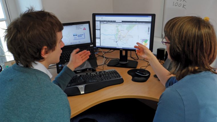
At Scottish Water, an interactive web-map has been developed that can be displayed through a web browser and served through the organisation’s intranet. This enables rapid, clear access to geospatial information and, as the viewers are open-source and browser-based, it can be accessed anywhere in the organisation without any “client side” software licence or installation. The Scottish Water Viewer offers:
- A variety of interchangeable map backgrounds
- Thematic layers of assets
- Selectable features
- Text search of attributes
- Exporting selected features to spreadsheets
- Simple buffers, mark-up and redline tools
Speed of access is crucial to its success. Conventional map production often takes days and produces static images. With the new system, anyone can make simple queries and map production can be completed in fewer than six clicks of a mouse.
Working with investment planning teams, two viewers were created showing asset information from a range of different sources. Several existing GIS layers were merged with new layers created from datasets such as standalone spreadsheets and geocoded addresses. This process has unearthed potential information that had been locked in “silos” by different formats and incompatible software. The reductionist design of the viewers stripped back functionality to create a simple and intuitive user interface with only the most essential tools. Extra functionality can be added or created, but only when a clear need is identified.
The basis of the development is MapGuide OS/Maestro (5), a simple server and web-map authoring tool. This comes complete with an intuitive graphical user interface, which speeds up map production, with limited training or specialist skills required. Changes to symbology and the addition of new layers are straightforward. The GUI was essential for a progressive transfer of ownership to Scottish Water business planners and shows the maturity of open-source mapping solutions. The rapid start-up, from download to a fully functioning web map, has enabled the creation of an agile, easily deployable product.
Hands-on Development
An agile project management approach was adopted by Kemeling, differing from the conventional “waterfall” method – a linear, sequential design process from start to end – used extensively in large IT projects. It embraces and plans for changes during development. Projects that alter business processes and offer new capabilities inevitably need tailoring and change as they progress and it is essential to work closely with those that will use and maintain the system (6).
For Scottish Water, a simple viewer was rapidly deployed allowing instant access from the very start of project. This enabled direct, hands-on use of the system by the client as it developed. Small changes to symbology, or thematic layers, were performed quickly. Successes were recorded and benefits shared from the very start. With any new software deployment, remaining agile is crucial to ensuring that morale is kept high, learning curves are minimised and small problems addressed promptly. This prevents the deluge inherent in waterfall led projects where a completed system is delivered in one step at the end of the project only to find that it does not fully meet expectations or requirements.
Future Development
Flexibility and inter-connectivity are inherent to open-source systems, with the consequence that expanding capabilities is simplified. From the huge range of tools available within the open-source community, functionality can develop as and when required. The benefit of open-source software is the ability to alter and retrofit components, with limited impact on service. This stands in stark contrast to proprietary offerings.
After delivery of the initial project for Scottish Water, a need for automated updates was highlighted. The requirements for an ETL (extract, transform and load) tool and a more robust spatial database were also clear. GeoKettle (7) as an ETL tool was quickly integrated and provides a sophisticated and mature system for uploading geospatial data. PostgreSQL/PostGIS (8) is an industry leading relational database system with spatial extension and provides another building block for a mature and robust system. The adoption of these components was possible thanks to unrestrictive licensing and the flexible, inter-connective nature of open source software.
Benefits
The power of visualising information on a map cannot be underestimated. In this instance, more informed decision-making was immediately realised. Breaking away from conventional proprietary licences allows anyone with the rights to the content to access the information. Growth among users and across departments has only been restricted by the confidential nature of some information. Previously cluttered and dense spreadsheets have become elegant thematic layers in the viewers. Creating a shared space for information has reduced misunderstanding and duplication between departments. The benefits of the system have led to a reduction in time taken to locate and identify assets, increasing efficiency. Within Scottish Water, its SR15 investment programme is responsible for planning £1.8 billion worth of capital maintenance between 2015 and 2021. An efficiency gain of only 1% as a result of better access to data and better understanding of interaction between programmes would result in £18 million worth of saving.
Conclusion
A combination of the right software and the right project management should enable a flexible and bespoke approach that will deliver clear benefits from the very start of a project. Agile management and open-source components, used together, can produce a successful, sustainable and expandable system with a potentially unlimited lifespan. Compared with proprietary software, produced and often delivered using waterfall project management, the benefits are clear.
At Scottish Water, the target users of the system were an integral part of the development process, so ownership and training were implemented gradually. Successes and benefits are recorded throughout and new, unexpected, benefits are still being realised. The successful development and continuing expansion of the system are testament to the process of building from successive small incremental steps and should be seen as an example for a brighter future for information management in asset rich companies.
------------------------------
References
- McKinsey Global Institute. Big data: The next frontier for innovation, competition and productivity. 2011 (Accessed 19/02/2014)
- Andrew McAfee and Erik Brynjolfsson, Harvard Business Review. Big Data: The Management Revolution. 2012 (Accessed 19/02/2014)
- Kemeling Consulting (Accessed 19/02/2014)
- Scottish Water (Accessed 19/02/2014)
- MapGuide OS/Maestro (Accessed: 19/02/2014)
- Arnulf Christl. Agile Project Management (Accessed 19/02/2014)
- GeoKettle (Accessed 19/02/2014)
- PostgreSQL/PostGIS (Accessed 19/02/2014)
This article was published in GIS Professional April 2014

Value staying current with geomatics?
Stay on the map with our expertly curated newsletters.
We provide educational insights, industry updates, and inspiring stories to help you learn, grow, and reach your full potential in your field. Don't miss out - subscribe today and ensure you're always informed, educated, and inspired.
Choose your newsletter(s)


