Combining Theory with Practice - Essentials for the Future Workplace
The University of Aberdeen has an enviable reputation for geoscience, GIS teaching and research. Dr David Green introduces the challenging MSc in GIS programme.
All of the modules we teach as part of the MSc in GIS degree programme at the University of Aberdeen combine theory and practice into 11-week modules. The modules form the basis for the second half-session (SHS) of the academic year and are intended to provide students with an emphasis on practical work as preparation for their dissertation to be carried out in the summer months.
Whilst all of the modules continue to provide theoretical background through lectures, guest speakers, and reading in magazines, books, and journals, the main focus of the module work and assessments is directed towards putting knowledge and understanding gained in the first half of the academic year into a practical context, using projects and practical exercises for the assessment.
In three of the four modules comprising the coursework for the second half-session, students have to undertake extended practical exercises to bring together their knowledge and understanding of geospatial technologies (GIS, remote sensing, digital mapping, cartography, databases, mobile GIS and Apps, and Internet mapping) from the first half-session into a practical and problem-solving environment. The practical work usually takes the form of both short 6-week individual mini-projects (with limited staff input) and 12-week group-work projects with external input from research, commerce, and government sectors.
Research Projects
In these modules students are expected to carry out a small piece of research involving the sourcing, inputting, processing, and analysis of various geospatial datasets, utilising various different software packages (including industry standard and Opensource software as well as utilities), writing up a report with a literature review, preparing short presentations and designing a scientific poster. Group work projects include an assessment of individual roles in the project as well as contact with a ‘client’ and an advisor, and some data collection activities utilising smartphone Apps, and UAVs for aerial imagery, e.g. colour, NDVI.
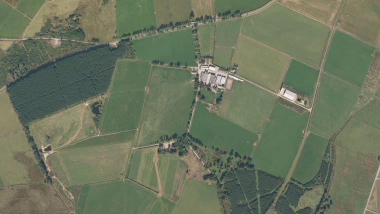
An Example
For the project work, a GIS and image-based farm mapping exercise is undertaken. Students are divided into groups representing GIS consultancies and given the task of responding to an invitation by a farm client to tender for a farm-mapping project. They must provide a name and design a logo for their consultancy, a time management plan for the work, a budget breakdown and a list of deliverables. As part of the exercise, the consultancies must complete an outline presentation of their proposed work to the client – a farmer – and a business consultant. Following feedback, the consultancies proceed to undertake the work outlined in their proposal. Each consultancy is provided with comprehensive data and information about the farm including farm records, maps, aerial photographs, and various documents (mostly in analogue format), and are hosted by the farmer for a number of site visits that cover some of the general background and context about the farm.
Following a question and answer session with the farmer and the business consultant, the consultancies set about the task that includes examining the information provided, and undertaking research. They are introduced to digital image processing (DIP) theory and practice to allow them to process satellite imagery from Landsat TM and ESA’s Sentinel as the basis for producing a land-use/land-cover map for the farm. In addition, students are introduced to the role of UAVs in remote sensing and mapping for precision agriculture applications, CAA regulations, safe operation of UAVs, and a range of low-cost sensors used to collect photographic and video imagery, as well as to build 3D terrain and feature models.
Once complete, students present their work to the farmer and the business consultant using Powerpoint. They also submit their work as a final report, together with deliverables, and an A0 poster as a summary of the work undertaken.
A Challenge
This is challenging work for students, but it offers an opportunity to: work as a team; undertake research; explore the scientific literature; collect their own data; process, analyse and integrate data from often disparate sources; work to a budget; manage their time effectively; write a report; interact with clients; and communicate their work in different ways and formats. Students enjoy this activity, especially as it prepares them for the work and discipline to complete their dissertation. It also has a positive benefit as they prepare for the workplace.
Acknowledgements
Thanks to: Roger Polson – Knock Farm, Huntly; Jason J Hagon and Ryan Peck for the project output illustrations.
This article was published in GIS Professional April 2017

Value staying current with geomatics?
Stay on the map with our expertly curated newsletters.
We provide educational insights, industry updates, and inspiring stories to help you learn, grow, and reach your full potential in your field. Don't miss out - subscribe today and ensure you're always informed, educated, and inspired.
Choose your newsletter(s)


