GeoInformation Group Imagery Helps Map London’s Olympic Legacy
The GeoInformation Group, publishers of mapping and geospatial information products, has supplied stunning UAV aerial imagery of three London 2012 venues owned and managed by Lee Valley Regional Park Authority as part of its maintenance programme.
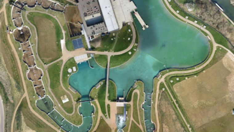
A lightweight Unmanned Aerial Vehicle (UAV) was used to carry out the survey of the Authority’s sporting venues in Queen Elizabeth Olympic Park – Lee Valley Hockey and Tennis Centre and Lee Valley VeloPark – and Lee Valley White Water Centre situated in Hertfordshire, captured at a resolution between 2-5cm per pixel and an area totalling 4km2.
Utilising a UAV offered a considerable advantage over its manned aircraft counterpart. Two of the three sites were within the immediate environs of London City Airport making UK Civil Aviation Authority (CAA) permissions more difficult to obtain. A UAV offered high-resolution imagery with no major concerns on flight permissions making it the first time special permission was received from the CAA to fly a fixed-wing UAV within London airspace.
“The quality of the image database is excellent and has already been used for data capture on all three sites”, comments Lee Valley Park Regional Park Authority’s Performance Manager. “Despite having to change dates for image acquisition due to the late completion of venues, The GeoInformation Group has worked to ensure that the Authority received exactly what was required and has gone over and above our expectations.”
Captured photos were transformed into orthomosaics and are being used by Lee Valley Regional Park Authority primarily as a base map in the absence of current mapping. The database is predominantly being utilised in the day to day operation and maintenance of the Authority’s sporting venues. It is also proving valuable in assisting issues relating to land ownership boundaries, plotting street furniture and mapping the mountain bike trail.
“Working with The GeoInformation Group has been one of the least stressful commissions the Authority has undertaken. From initial quote to final delivery of images, the team has been professional and adaptable throughout,” concludes Lee Valley Regional Park Authority’s performance manager.

Value staying current with geomatics?
Stay on the map with our expertly curated newsletters.
We provide educational insights, industry updates, and inspiring stories to help you learn, grow, and reach your full potential in your field. Don't miss out - subscribe today and ensure you're always informed, educated, and inspired.
Choose your newsletter(s)


