GeoSLAM Launches Upgrade to Hub Software
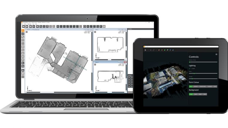
GeoSLAM, a geospatial specialist company, has announced the latest update for its software suite, GeoSLAM Hub. GeoSLAM Hub 5.2 places user experience at the heart of the software and allows all customers of the ZEB family – both long-time and new – to access the latest features with universal compatibility. With the new check-in, check-out licensing, users can publish and share their work from the office and field while remotely collaborating on the datasets with co-workers all over the world, without the need for a dongle.
In the latest update, GeoSLAM has created a number of new editions of the GeoSLAM Draw module, including additional packages that provide specific features to suit a range of different industries and projects. The Draw Start module – which comes as standard for every user – allows clients to create simple floor plans and geo-reference data, as well as use 360-degree panoramic imagery with all datasets.
If users want to share and deliver these floorplans with their coworkers, they can upgrade to the Draw Plan module, which includes a Web Export tool to produce PDF and HTML files that allows all stakeholders to collaborate, with or without a license. Users can also examine GeoSLAM data in Autodesk thanks to RCP file export.
The Draw BIM module is ideal for those carrying out technical surveys or building 3D models. Using the 4Revit tool, the module improves workflows for the 3D modelling of point clouds by communicating directly with Autodesk Revit. This helps clients produce complex deliverables and can include data from different surveying tools.
Finally, the Draw Pro module provides the complete GeoSLAM Draw package, including all of the previous features, as well as additional elements for volume calculations and profiling, including the creation of mesh DTMs and surface change measurements.
“Our transformative technology is as much about the software as it is the hardware. The introduction of sector modules within Draw is recognition of the importance of well-designed digital workflows specific to our customers’ applications. GeoSLAM Hub was already the go-to software for processing and visualizing geospatial data, and we’re excited to offer our clients a more flexible and innovative product.” said GeoSLAM CEO, Shelly Copsey.
For more information, visit www.geoslam.com

Value staying current with geomatics?
Stay on the map with our expertly curated newsletters.
We provide educational insights, industry updates, and inspiring stories to help you learn, grow, and reach your full potential in your field. Don't miss out - subscribe today and ensure you're always informed, educated, and inspired.
Choose your newsletter(s)


