Healthy Workout for GNSS Technology
For some companies, giving back to the community is part of a day’s work. That certainly is the case with Dillon Consulting, a professional consulting organisation in Ontario, Canada, founded in 1946 by two military veterans. The company now has offices across the country and a well-deserved reputation for quality and high values.
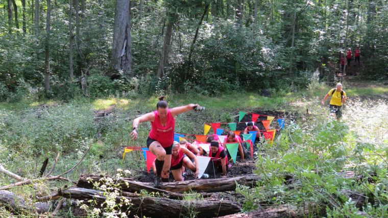
Dillon strongly believes in supporting the local community, and a favourite charity is the Canadian Cancer Society. For the last four years, Dillon has been a co-sponsor of the ladies-only “mud run”, called the Halton Mudmoiselle, which raises funds for cancer research and support services. Last year, when the organising committee chose a new location for the race, Dillon saw it as an opportunity to help the organisers while also testing the latest Esri technology.
The race previously had been held at the local conservation authority. “We were limited in obstacles and what we could physically alter onsite,” said Sarah Galloway, a GIS specialist with Dillon. “With a mud run, we wanted it muddy. We wanted to up the ante.” And they did. The new site is a maple farm, with dense undergrowth and thick trees. The site’s poor cell coverage, however, could turn what appeared to be a simple mapping project into a logistical nightmare. Dillon looked to GIS tools such as mobile data collection and mapping to layout the trails.
Preparing for the Event
The Dillon team and a group from the local chapter of the Cancer Society visited the farm four months before the race to see what they could do with the space. They asked the property owner if they could flag potential sites for creating a trail. The owner would be able to use the trail later to access the back end of the property, so the project would be a collaborative effort.
The maple farm has forested areas with very thick brush, and the trails would need to cut through the tree cover. “It was the first time a run had been held at the farm and we were bushwhackers,” said Galloway. “There was very dense undergrowth, so we couldn’t get far in our first few times on site.”
On top of that, the property was notorious for weak cellular signals. “We thought this would be a great test for Trimble Catalyst and Esri Collector,” said Galloway, who had been reading about the Catalyst technology, a software-defined GNSS receiver that works with Android-powered tablets and smartphones. Collector for ArcGIS (EAP version) enables improved and informed decision-making by putting mapping and data collection capabilities in the hands of the field worker. “We were wondering if Catalyst would be easier to use and we wanted to test its accuracy under such poor conditions compared to other GPS products,” she added. The Mudmoiselle run provided a good opportunity to find out.
Before heading to the site, Galloway set up a simple online map in ArcGIS Online that could be opened in Collector on both a tablet and smartphone that would track the route and obstacle locations. The online map consisted of the property boundary, current aerial photos, and waypoints. The waypoints had two input fields: Fields ID, which would auto-populate with data so they could track the route, and a comment field used to note any potential obstacles. Collector can take and store images and photos, which was handy when documenting the obstacles and also for viewing the area later without returning to the site.
Dillon compared Catalyst’s performance with their existing Trimble Pro 6H receiver and ArcPad using corrections from Cansel Can-Net real-time network. “The Trimble Pro 6H is bigger and we didn’t need the sub-metre accuracy it provided,” Galloway explained. Catalyst can obtain positions in real-time with accuracy ranging from metre level to two centimetres. “When you want to get to the decimetre level, you need a clear view of the sky. With Catalyst, the site team could navigate woodland areas and tough terrain carrying little more than a smartphone.”
On the first day of Catalyst performance testing, Galloway and Dillon’s GIS technical lead, John Fairs, hiked the site for four hours. The Catalyst antenna, along with the Pro 6H, was mounted on a Trimble backpack. Catalyst and Collector were both running on Fairs’ Android phone. The Pro 6H was connected to a Windows tablet using ArcPad that Galloway was using. Fairs and Galloway were collecting data simultaneously on each of the devices so they could later compare the data back in the office.
The Course Takes Shape
“We flagged potential obstacles, such as downed trees, which we could use as natural race obstacles,” Galloway said. “The race is 5K and we marked 2.7km of possible trail with tape and points so we could see where it was when we were back in the office. We were getting centimetre accuracy on both units. Using Collector made it easy for us to view the trail and location of the obstacles back in the office. This helped us to make decisions on where we should focus the remaining 2.5km of trail.
“There were a few swampy areas, which we incorporated to ensure the event lived up to its name. But the ground was drier than we thought, which was good because the trail was very rocky. We didn’t bring much mud in this year but next year we will. It was easy to get lost out there because everything looks the same, but when you have the right equipment with you, you feel more comfortable.” added Galloway.
Galloway and Fairs marked key waypoints and features for possible routes, and then showed the property owner their plan. They returned to the property whenever possible to continue the layout and help clear the trails. “One weekend, we used Catalyst to mark 2.5km worth of trail and another time we marked about 50 metres. In that environment, you have to have a clear path because the brush is so dense on both sides. Before Catalyst, we’d place flags on bushes and trees as markers for the trail. Catalyst made it much easier to layout the course.” Galloway and other fundraising volunteers also helped the owner trim and clear underbrush when they were marking trails.
Strong Performance in Record Time
“Catalyst performed beyond expectations, especially in such heavy tree cover,” said Galloway. “With averaging enabled in Esri Collector, we were routinely getting an accuracy of 80cm or better, which we thought was excellent given the site location and cell coverage challenges, as well as tree cover.” To boot, it was an overcast, rainy day.
Though carrying equipment is part of a field tech’s job, Catalyst made the job easier. “It was so lightweight and had the accuracy we needed in poor environmental conditions. The added bonus of using smaller hardware made trekking through thick vegetation cover a lot easier.”
Galloway regularly shared Catalyst’s AGOL web map with event organisers and participants to show the progress of the course. The combination of accurate trail layouts and obstacle locations overlaid on current air photos (provided by Canadian company First Base Solutions) was critical to creating a successful race layout.
Mud, Sweat and Cheers
They also created an Esri Story Map for race participants so they could see their accomplishment. To create the map, they used data collected in the field as well as photos taken during the event by photographers and volunteers. Participants had access to the Mudmoiselle Halton Story Map, where they could see the route and location of obstacles. The Story Map was sent out as a link on social media (i.e., Canadian Cancer society’s twitter and Facebook account). “This was a tough project because it was the first year at the maple farm and it was a site with lots of roadblocks,” Galloway said. “But everything was finished in time for the race. I am looking forward to working on next year’s race, and at Dillon, we are looking forward to using Catalyst in even more challenging conditions.”

Value staying current with geomatics?
Stay on the map with our expertly curated newsletters.
We provide educational insights, industry updates, and inspiring stories to help you learn, grow, and reach your full potential in your field. Don't miss out - subscribe today and ensure you're always informed, educated, and inspired.
Choose your newsletter(s)


