New Technologies and Historic Environment Data
Former CEO of the Royal Commission on the Ancient and Historical Monuments of Scotland (RCAHMS) Diana Murray reviews the impact of new technology on archaeology since she joined the heritage sector 35 years ago.
Nearly 20 years ago I organised a seminar that looked at new techniques and new knowledge in archaeology. ‘The purpose of the session’, I wrote, ‘was to take a glimpse of the future, exploring new technologies which could help the effective management and sharing of data which would lead to a better understanding of the past.’ In this vision, I imagined a time when, from the comfort of your own home, you could make an enquiry online that would call on information from any available source, with location maps, distribution analysis, images and associated data to answer an almost limitless set of questions about the historic environment (it was the very early days of the internet). Well, of course, this vision is now very much a reality and we can even do this on mobile technology, which was way outside our thinking back then.
Historic Environment professionals are always keen to harness available and emerging technologies, not least in the recording and curation of information and in the democratisation of access that makes people more engaged with the Historic Environment, and the job of the professionals better understood. Today, we are looking at new methodologies, such as machine-readable techniques and new thinking such as linked data, which will speed up data collection and open up new avenues of analytics.
Linking Data
An example of such potential is to link Historic Environment data across sectoral boundaries in order to demonstrate the relevance of the Historic Environment to a wider agenda. For example, that a sense of place and identity, interest in cultural heritage, and associated volunteering effort can have a significant impact on self-worth, and physical and mental well-being. The technology exists and the data is there and is only waiting for the standards to be set and the links to be made.
The power of integrating information is not a new concept. Information about the historic environment (antiquities as it was termed) has been part of the OS field survey specification for nearly 200 years until the end of the 20th century. It was brought together with accurate topographic mapping on published maps used universally by those engaged in any form of work relating to planning, land use or land management. Today powerful databases, digital mapping and GI technologies, internet and web developments enable heritage managers to hold and manipulate their own data interactively with spatial geographies; which in turn has opened up unimaginable opportunities and raised user expectations.
Alongside the opportunities that this brings, is the recognition that there needs to be a co-ordinated national approach if we are to serve our stakeholders well. Encouraging this collaboration and demonstrating the benefits of mutual co-operation has resulted in the National Mapping of the Historic Environment for Scotland. This provides the bedrock on which decision making can be made about how to deal with change. It helps establish the criteria that are used relating to significance of monument and landscape types and the consequent approach to conservation or recording, as well as providing access for interested public users.
The Long-term View
Providing authentic national coverage is achieved firstly by taking the long-term view: incorporating work that has been accumulated over many years of research and survey by RCAHMS and others and which form the National Record of the Historic Environment, now in Historic Environment Scotland (HES). This includes field surveys, aerial and remotely sensed data, desk-based recording and research programmes, and excavation plans which can themselves be spatially and chronologically fitted into landscape mapping. In order to establish a truly national picture, it also depends on collaboration across the Historic Environment Sector with all those who are involved in data capture and who have a requirement or desire to make that public.
The recent survey of St Kilda provides an example of data capture involving over 15 years of research and interpretation. Such detailed ground surveys have been a typical method of archaeological survey for over 100 years, but this survey illustrates the way different modern techniques combine to produce accurate mapping of the historic landscape using rectified aerial photography, and GPS survey methods, together with detailed on-site recording. The results have been published as a popular book*, and the detailed information, survey drawings, images and the mapping of this fascinating archipelago are incorporated into the National Record of the Historic Environment and are available online.
Crop-mark Capture
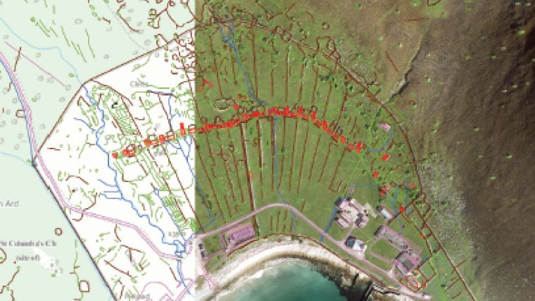
Another important data capture methodology is low-level aerial survey (flown at 1-2000 feet). Targeted in optimum conditions at specific historic environment sites and at a rate of capture of 2-3000 per year, it has resulted in a wide coverage of the Scottish landscape. This technique includes low-light photography of low relief sites; and crop-mark survey which typically reveals archaeology as the conditions beneath the ground cause stresses in the crop at specific times of year. This creates the distinctive marks that can be photographed from the air and interpreted as particular types of monument. Farming methodologies with precision farming is now beginning to remove this effect from observation and new techniques are being explored including spectral imaging, lidar and low-level drone surveys. These provide innovative ways for not only capturing, but also analysing information which can be manipulated digitally to enhance features.
The National Record of the Historic Environment at HES houses over 20 million photographs from all over the world including blanket coverage of Scotland from 1940s to the end of the 20th century. This collection provided the source material for a 20-year desk-based data collection programme in which the combination of maps and photographs old and new has been used to analyse the historic land use of Scotland. This collaborative project was developed to help the understanding of the landscape and to enable the evaluation of areas of relics of historical interest vulnerable to change.
Defining Boundaries
One of the programmes of data enrichment currently underway, is to define the extent of sites to replace single centre point locations. Defining the boundaries of historical sites for mapping purposes is not as straightforward as you might imagine. The statutory boundary for monument protection does not coincide necessarily with the known spread of a site; while defining the extent of a site known only through remote sensing can be quite subjective. So the journey to determining how to show site extents has been a long one and has involved developing and agreeing a defined set of standards of polygonisation across the sector so that the data is exchangeable between partners. Based on these standards, however, it has been possible in collaboration with a number of participating organisations to build another layer of the National Map the Historic Environment of Scotland.
Making this richly layered information widely available is a core responsibility of public sector organisations. Searches to the online services provided by HES have escalated to a staggering 16.5 million worldwide and some 20,000 images are fulfilled annually through direct online services.
Single Hub
Key to the success of the online delivery of a national dataset is that the source data is maintained in a single data hub, which can be accessed by a number of tailored services including WFS and WMS. Also key to success is the collaborative partnerships across the Historic Environment sector in Scotland that provides users with access to a ‘one-stop-shop’ for data drawn from a number of reliable sources. The basic principles that have been adopted are:
- Metadata that links data internally and externally which is key to user discovery across different datasets.
- The application or if not available, the joint development of industry standards and controlled terminologies,
- ntroducing controlled gazetteers linking historic to modern data allowing past and present geographies to be linked, which is key to historic archive discovery
- Historic Environment data is spatially enabled to underpin the operation of the user services and the integration of data. This allows users to make their own associations and links.
The development across the sector of a shifting relationship with users, specifically the introduction of a two-way dialogue, and a presumption that users will be able to make their own understanding and meaning without specialist intervention or expert advice. The focus, therefore, moves to enriching the data content including public contributions. These principles underpin many of the online services available. Examples include:
Canmore – the main online service for users which combines access to location maps, survey reports, photographs and digital images of archives including historical material and modern surveys. A new mapping application is about to be launched as part of this service combining a number of spatial datasets, including site extents, which have not previously been available online. https://canmore.org.uk/ Related to this is:
My Canmore – which gives access for the public to upload information and images and contribute to the national endeavour of creating a National Record of the Historic Environment.
Scotland’s Places – is a partnership site aimed at the family history sector, giving access to the digitised records of three National collections delivered in real time, using controlled gazetteers that link historic to modern places. This opens a non-spatial archive to spatial searches and the site includes opportunities for volunteers to transcribe hand-written manuscripts to make them searchable by people or place. www.scotlandsplaces.gov.uk/
Britain from Above – is a partnership site which is specifically designed as an online crowdsourcing project. Over 1 million users last year helped to identify and plot the content of the Aerofilms collection. www.britainfromabove.org.uk/ There are also online services primarily designed for the professional or specialist user, but open to all. Here data standards, metadata links and spatially-enabled data are key to their operation.
Pastmap – is a shared site for heritage information that combines data from a number of different datasets managed by a range of professional bodies, locally and nationally but which provides a ‘one stop shop’ for land managers and planners. http://pastmap.org.uk/
HLAmap – is a Scotland-wide view of land use in modern and past times designed to show how the landscape has changed over time. http://hlamap.org.uk/
Buildings at Risk Register – lists vulnerable listed buildings at risk of decay or demolition and allows the public to nominate buildings for the register www.buildingsatrisk.org.uk/
NCAP - is the online site for examining and purchasing aerial photography cover of the UK and countries across the world where Britain has had an interest (generally military). The collection consists of over 20 million photographs that are steadily being digitised and geo-located. http://ncap.org.uk/
Spatial and data technologies have become increasingly interactive, web services are providing more powerful delivery tools and an ever more sophisticated range of techniques is available for data capture. The technology is no longer a barrier to what we can now achieve. More important is ensuring that the data is enriched in a way that can provide answers to the questions we need answering, and those depend not just on systems and collaborations, but on a clear vision of what we need and what our stakeholders require.
This article was published in GIS Professional August 2016

Value staying current with geomatics?
Stay on the map with our expertly curated newsletters.
We provide educational insights, industry updates, and inspiring stories to help you learn, grow, and reach your full potential in your field. Don't miss out - subscribe today and ensure you're always informed, educated, and inspired.
Choose your newsletter(s)


