Pointfuse Point Cloud Software Transforms Design of Construction
Swanton Consulting has transformed the design of temporary works – such as façade and basement retention – using a software innovation that creates instant 3D models from laser scanner data. Processing of the millions of individual 3D laser scan measurements, known collectively as point clouds, used to take Swanton up to two weeks. However, since introducing Pointfuse V2 point cloud processing software, Swanton can now produce highly accurate vector models, suitable for immediate use by design engineers, in less than a day.
Swanton Consulting specializes in the design of temporary works, deep basements, façade retentions, retaining walls, specialist structural elements and contractor delegated design elements. Working alongside design teams and contractors, Swanton is one of the leading providers of façade retention engineering solutions in London.
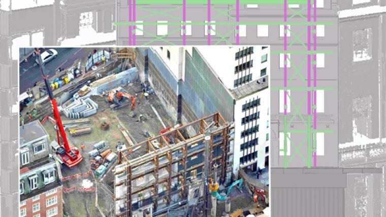
“One of the first projects we tested Pointfuse on was the design of steel structure to support the façade of two Grade II listed structures in London’s prestigious Mayfair,” commented Pearse McMahon, Senior Technician at Swanton Consulting. “The façade scheme was developed and coordinated with the permanent works, with the layout driven heavily by the use of 3D modeling from point cloud surveys.”
Data to support the design of the façade steel work was collected by Swanton’s Testing and Monitoring division using a Leica ScanStation laser scanner. Originally, the vast point cloud was imported into the 3D construction modeling software Tekla Structures, produced by Trimble. The 1.5 Gb DXF CAD file, comprising more the six million cross hair points, then took the best part of two weeks to process into a usable model onto which the steel structure framework could be positioned.
Following the acquisition of Pointfuse V2 software, the original point cloud was reprocessed to create a 3D model of the façade in the open IFC format for onward use in a variety of software packages, including Trimble’s Tekla and AutoCAD Revit. However, rather than taking two weeks to create usable models, the Pointfuse output was ready for use by the steel work designers in less than a day.
“Pointfuse will transform our use of laser scanned data,” continued McMahon. “With highly accurate vector models available for use by design teams in hours rather than days, we are more efficient and more effective. Savings we can pass on to construction partners and end clients.”

Value staying current with geomatics?
Stay on the map with our expertly curated newsletters.
We provide educational insights, industry updates, and inspiring stories to help you learn, grow, and reach your full potential in your field. Don't miss out - subscribe today and ensure you're always informed, educated, and inspired.
Choose your newsletter(s)


