Reality IMT Introduces 360 Video Mapping Software
Reality Imaging and Mapping Technologies, a market-leading 360 technology provider, has announced the release of OcuMap, a comprehensive software platform for geospatial media that brings together videos, images and maps. Organisations can take advantage of OcuMap to upload, manage and share their aerial and street level imagery in an integrated environment that will help them realise efficiency gains, as large infrastructure assets can now be visualised and accessed without leaving the office.
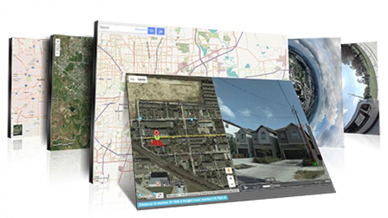
OcuMap is a cloud-based 360 degrees viewer with geo-referencing capabilities, offering a single dashboard with maps, imagery, and videos for remote decision making. Google Street View imagery and 2D map data can be used alongside aerial or street level video imagery, with functionality to add tags and annotation features. Because the OcuMap is camera hardware-agnostic, users can upload all sorts of geo-referenced video imagery, and view it in 360 degrees using no less than three different display modes. Finally, additional geo-referencing capabilities enable users to create hotspots and take 3D measurements inside ground-level imagery and download the results.
“OcuMap was designed with the field engineer in mind. We created a solution that enables them to make fast and accurate decisions about work in the field, bypassing the need for expensive and highly technical data products, expertise and software”, says Ala Hamdan, CEO of Reality IMT. “OcuMap offers a great user experience, making it the perfect choice for applications such as road and highway construction, public works and infrastructure, drone operators and mobile mapping companies”.
The solution was road-tested by The City of Houston’s Public Works and Engineering (PWE) department, who teamed up with Reality IMT to explore the possibilities of using UAV-based video imagery. Together, they investigated how it could be applied to identify, prioritise and maintain off-road ditches in order to prevent flooding issues. A sample video is available here. The Reality IMT team used OcuMap to manage all the UAV data, tag defects online, and export the data based on the priorities set forth by the City.
Using UAV-based video imagery, the inspection efficiency increased to more than 60%. Whereas conventional inspections would take about 8 months to document and prioritize the 100 mile long off-road ditch network of Houston, thanks to using drone-based imagery, it took only 45 days – a process including visually documenting, mapping, and geo-tagging defects.

Value staying current with geomatics?
Stay on the map with our expertly curated newsletters.
We provide educational insights, industry updates, and inspiring stories to help you learn, grow, and reach your full potential in your field. Don't miss out - subscribe today and ensure you're always informed, educated, and inspired.
Choose your newsletter(s)


