Creating a New Normal in the Everglades
Professional grade GPS linked to an iPad is bringing significant efficiency gains in data capture to a water management organisation, reports Mary Jo Wagner.
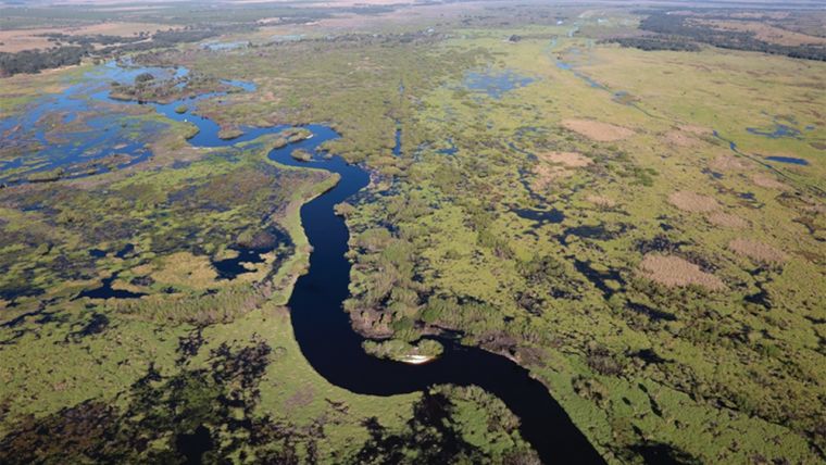
Based in West Palm Beach, the South Florida Water Management District (SFWMD) covers 16 counties stretching from Orlando to the Florida Keys, including the unique and intricate Everglades freshwater wetland. The oldest and largest of the state’s five water management districts, the 67-year old SFWMD strives to maintain a delicate balance between safeguarding the water needs of the natural environment and the competing water-supply demands of 8.1 million residents.
As part of its extensive responsibilities for south Florida’s water-rich environment, the District has been at the helm of significant natural resource. One of the most ambitious initiatives is the Kissimmee River Restoration Project (KRRP), which aims to repair damage from past overly aggressive flood-control measures.
With the scope of the KRRP and the extent of its monitoring area – about 17,000 hectares (44,200 acres) – the SFWMD created the lakes and river ecosystems section (LRES) in 2006 to act as a dedicated team to evaluate environmental changes and ensure the ecology of the region is thriving throughout the restoration phases.
New Technology Helps Measure Success
Measuring the environmental successes, however, was a significant challenge for LRES personnel because they were trying to monitor and map a very fluid environment with static, labour- intensive tools – paper notebooks and maps, hard-copy geospatial imagery and consumer-grade GPS technology.
That all changed, however, in 2015. After a ten-year digital transformation designed to bring data-collection efficiency, versatility and accuracy to the LRES, the department implemented a new technological solution: a Trimble R1 GNSS receiver connected via Bluetooth to an iPad running the Esri Collector for ArcGIS app. The new combination of iPads paired with R1 GNSS receivers has not only shredded the paper trail for the LRES, it’s giving staff the smart tools they need to more efficiently and accurately monitor and map diverse vegetation species in the KRRP and produce deliverables with higher confidence.
Boatloads of Data
Given the size of the KRRP monitoring area, the LRES uses both airboats and helicopters to survey and map the vegetation – field work that is coordinated with aerial surveys flown every three years for large area coverage. The focus is on studying and mapping the predominant emergent vegetation – plants above the soil or water surface – which is a key indicator of the ecosystems’ overall health.
Historically, staff needed to print out reams of paper before embarking on their field assessments. However, for the 2015 field surveys, LRES environmental scientist Lawrence Spencer fielded the new Trimble R1/iPad combination.
Rather than printing paper, Spencer loaded the iPad with all the relevant apps and maps he needed. Travelling by airboat, he used the R1 in combination with the iPad to navigate to predetermined sample areas. Once at a location, he stopped, located the centre of the vegetation cluster and captured a precise GNSS ground-control point (GCP) of that population, which was stored into the Collector app to provide an accurate position for mapping that vegetation class. Using templates, he recorded an array of attributes such as the plant type, its areal extent and its health, and attached photos of the area. Data collection complete, he navigated to the next location and recorded the vegetation there, a process he repeated every week for about six hours a day from April to June.
Using the R1 receiver, Spencer collected around 475 sub-metre accuracy GCPs – about three times the number of GCPs he could acquire previously. The GCPs are used both to generate signatures for air-photo-based vegetation classifications and to assess the accuracy of the final vegetation maps produced.
“The GNSS technology allows me to take more points, and higher quality points, in the time we have,” says Spencer. “These points allow me to create spectral signatures so I can better distinguish individual plant classes on the air photos and map them across the whole restoration site.”
More GCPS from the Air
In between airboat trips, Spencer also carried out vegetation surveys with a helicopter. Once he reached a predetermined location, the pilot hovered over the wetland and Spencer collected several GCPs with the R1 receiver, recorded plant attributes and took pictures of the vegetation below, all within less than 90 seconds. Then he flew on to the next sample area. In all, Spencer collected another 450 GCPs from the helicopter, giving him about 900 data points for the final maps. With only four hours per flight in which to collect data over the whole KRRP study area, efficiency is critical. The new system enables him to collect more information in less time and with less crew.
“In the past, I’d have another colleague, a laptop running Esri’s ArcPad, an old backpack GPS unit and paper maps in the helicopter,” says Spencer. “I often couldn’t take data points fast enough so I handwrote notes while my colleague took pictures of the vegetation. And we usually needed the full four hours to complete the work. With the R1 and iPad, we have reduced flight times by nearly 50% and I can acquire all the data, including photos, myself.”
Automated Map Production
In addition to the new field system, Spencer is also developing a more automated and accurate map production system using Trimble’s eCognition image analysis and land classification software. Historically, he manually drew polygons around vegetation populations on the digital infrared air photos, named each one by its signature and then used them to map the wetland vegetation. This time, he will transfer all of the data points he collected in the field, along with the 2015 aerial imagery, into eCognition to automatically classify and map the vegetation.
“With significantly more sub-metre accuracy data points, I’ll be able to classify the vegetation much more accurately and quickly,” says Spencer. “And I’ll be able to repeat and customize this process to produce any type of map needed. This flexibility and detail will help to better measure how well the vegetation and wildlife is responding to the KRRP.”
The Trimble R1 and iPad combination has not only improved the data-collection efficiency and the ability to readily share information within the LRES, it has also attracted other colleagues at SFWMD who see the benefits of this versatile system for their own work. The combined system may indeed become the new normal for acquiring data in the field.
This article was published in GIS Professional February 2017

Value staying current with geomatics?
Stay on the map with our expertly curated newsletters.
We provide educational insights, industry updates, and inspiring stories to help you learn, grow, and reach your full potential in your field. Don't miss out - subscribe today and ensure you're always informed, educated, and inspired.
Choose your newsletter(s)


