Eye-bot Aerial Solutions Creates Highly Accurate 3D Vertical Monopole Models
ContextCapture Safely Collects More Data Faster to Build Precise Reality Meshes
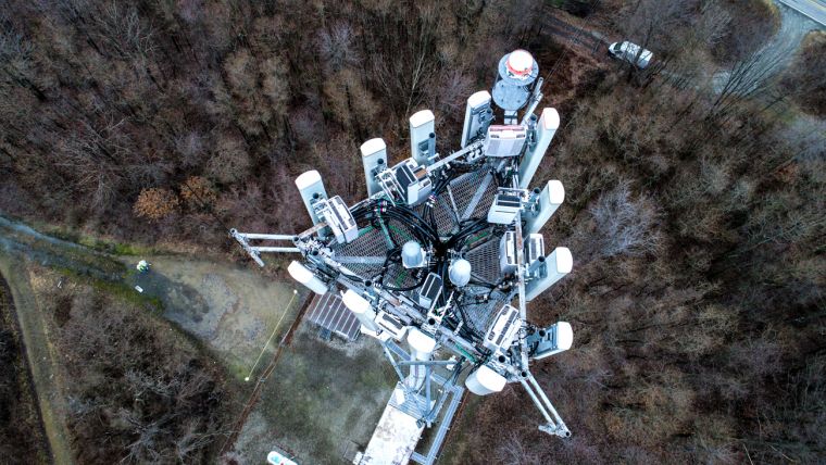
In 2017, Eye-bot Aerial Solutions, a drone service company, completed a 3D reality model of cell tower antennas in Springdale, Pennsylvania. The project team at Eye-bot initiated the Springdale Monopole project to improve model fidelity, positional accuracy, and photo-realism by comprehensively modelling vertical monopole structures that feature transparent, complex cross-bracing. In the long term, Eye-bot strives to use the enhanced models to help create standardized 3D modelling workflows.
The organization specializes in using unmanned aerial vehicle (UAV) photogrammetry to generate 3D models of cell towers. Based in Pittsburgh, Pennsylvania, Eye-bot has worked within several industries, including industrial manufacturing, oil and gas, telecommunication, infrastructure, construction, insurance, and power and utilities. A Federal Aviation Administration-certified company, Eye-bot can inspect, monitor, aerial survey, and 3D model a variety of locations.
Difficulty Modelling Towers
The main challenge of the Springdale Monopole project was the characteristics of the cell tower antennas. Vertical monopole antenna towers are difficult to model solely with UAV photogrammetry and is even harder when the tower contains complex cross-bracing and is see through. These features are common in self-supporting, guyed towers, as was the case on this project. Because of these conditions, the team realized that it needed to incorporate Lidar scanning as part of the data capture process. A software application that could accommodate both survey methods was necessary. Eye-bot combined UAV photogrammetry with Lidar scans to easily create 3D models with Bentley’s ContextCapture.
“ContextCapture is the only software we’ve found that can use photogrammetry and Lidar scans together, giving it a unique advantage in this application,” said Jake Lydick, founder and CEO of Eye-bot.
The application also helped the project team fully utilize its equipment. Previously, Eye-bot had difficulty processing images greater than 40 megapixels. ContextCapture processed all high-resolution images without any issues. This capability allowed the project team to experiment with new data collection procedures, ultimately yielding a better model.
Sharing Modelling Information, Improving Safety and Reliability
Besides the technical benefits, ContextCapture also enabled Eye-bot to share project information with prospective clients. Eye-bot made the collected data available in a variety of formats. The project team also had a 3D mesh and 2D orthomosaic available through a hosted web portal, providing global access to the information. Additionally, clients or prospective clients can download and view the mesh and point cloud data in a CAD programme of their choice if they wanted to evaluate the models more thoroughly. ContextCapture’s interoperability makes this possible.
ContextCapture enabled Eye-bot to take and share precise measurements without visiting the site, improving safety for the project team. By using UAVs to capture the data and then inputting them into the reality modelling application, Eye-bot eliminated the danger of workers falling from the tower, which can occur using traditional climbing methods. In addition to personnel safety, the 3D reality models allowed the project team to analyze the safety of the tower itself, checking for structural deformities and other issues. Lastly, because of the ability to easily share these detailed models and information with all parties, Eye-bot reduced travel, reducing its carbon footprint. These models will allow for better-informed decisions, keeping everyone safer.
Updating Model Information
Eye-bot created an efficient and repeatable means of inspecting vertical monopoles, collecting more data with better accuracy in a faster and safer manner than traditional methods. The team can periodically update the models with ContextCapture to keep them current, providing accurate information about its clients’ assets.
ContextCapture increased Eye-bot’s efficiency from design and implementation to maintenance, expansion, and monitoring. By comparing 3D models, users can measure and monitor monopole alignment for any in the network. This practice helped Eye-bot and its clients create a single source of truth for their antenna data. Also, users can perform updates on a regular basis to ensure that the equipment is in good condition as well as monitor known issues before a physical correction is necessary. Once the user determines the required repair or upgrades, the workmen can reference the model when performing their tasks. The model will aid in project planning and material selection, increasing overall efficiency and quality of the project and reducing resource hours.
Saving Project Time, Improving Services
Eye-bot saved time and money using many different features in ContextCapture. The application’s master-engine program allowed users to distribute the workload over the network, reducing the amount of time required between data collection and project delivery. Also, ContextCapture’s interoperability with MicroStation allowed the team to produce a model that can be directly imported into the other application. This capability eliminated the need to convert the model to CAD format and further helped reduce the time between collection and delivery. Because the team could generate a web view of the model, Eye-bot could host its models on its own server, lowering the overall cost of service.
Additionally, these models will help Eye-bot attain more dependable wireless networks because the detailed, precise, and easily shareable models will enable technicians to catch service problems sooner. In a world that heavily depends on wireless communication, this reliability is crucial. ContextCapture’s capabilities allow the cell towers to be inspected and monitored faster, safer, and more reliably.

Value staying current with geomatics?
Stay on the map with our expertly curated newsletters.
We provide educational insights, industry updates, and inspiring stories to help you learn, grow, and reach your full potential in your field. Don't miss out - subscribe today and ensure you're always informed, educated, and inspired.
Choose your newsletter(s)


