Geospatial in the Video Game World - Interview with James Coote
Just how much crossover is there between the worlds of geospatial and video games? GIS Professional turned to Andy and James Coote, father and son working in different parts of the computer industry. Andy has been involved in geospatial for many years and will be familiar to many readers, whilst James is the director of an independent video game studio, Crystalline Green Ltd. Andy asked James to give us his take on where the worlds of geospatial and video games intersect.
Andy Coote: The geospatial industry can now provide 3D data at a very detailed level for any part of the world from London to Shanghai, covering both urban and many rural areas. Is this a valuable resource for the games industry?
James Coote: A lot depends on the particular needs of the individual game. Obviously, those set in a distant galaxy or fantasy universe won’t have much need for real-world spatial data. However, games like Grand Theft Auto, with a modern day cityscape setting, might. The other factor is the game’s genre. Take a strategy game in which players look down upon an area from a bird’s eye perspective, constructing a city or commanding an army of tanks and soldiers as they roll through the streets. Here, real-world geometry of the buildings and the layout of the roads could be useful. Take for instance, fellow independent developer, Danny Goodayle’s recent Project Root which used Open Street Map data of London to create a striking visual aesthetic for his game.
First person perspective games also occasionally use geospatial data. French publisher Ubisoft used photogrammetry to recreate large parts of downtown New York for their recent hit game, The Division. High resolution (1m or better) lidar datasets offer another alternative data source. However, as University of Greenwich’s Darrenlloyd Gent discovered when demonstrating this to his Game Design Course students, real-world data often needs extensive cleaning up before it can be used for a production game, with objects such as trees or the London Eye Ferris wheel creating a tangled mess of geometry.
The alternative for game designers is to procedurally generate their own content – handcrafting a set of buildings, vegetation and road sections before having the game stitch them together according to some set principles to create a believable world. Games such as Sir, You Are Being Hunted by developer Big Robot weaves together a patchwork of English countryside villages, at runtime, to create unique patterns on every “playthrough”. This has the edge over using static real-world data.
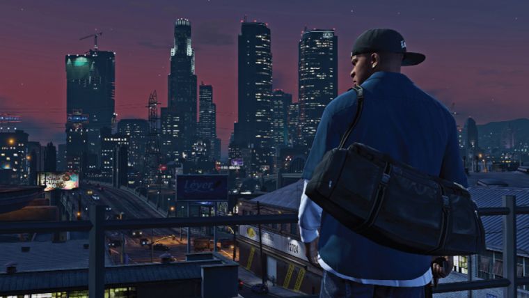
AC: So I’m imagining that in the next generation of (say) Grand Theft Auto you could choose your game to be set in New York, Central London or even Wimbledon. You would need 3D bird’s eye imagery and also Google Streetview-style panoramas. By processing such data it is also possible to extract into intelligent objects such as shop front detail, traffic lights and also to accurately show the lighting and shadows cast on the buildings.
JC: Grand Theft Auto, attracts many headlines for its less than politically correct content, skirts around its dubious world of sex, drugs and crime by working under the pretence of being satire. Players don’t really care if every detail is “super-accurate”, artistic licence is more important. For a game like this, the cities in which they are set are caricatures on Miami, New York or Los Angeles. In fact, a true-to-life scale game world of Los Angeles might involve a little too much sitting in traffic jams to be fun. Beyond the city centre, suburban areas like Wimbledon are actually pretty boring and likely to be areas players want to escape from when playing. Furthermore, for some games, there are legal and, for want of a better word, political reasons for avoiding using real-world locations. There may, for example, be sensitivities around a game that allows players to go on a shooting spree or blow up parts of a city which has suffered a terrorist attack or mass shooting.
AC: It seems like reality has to be compromised often for the game to be fun. So, are there any “sweet spots” where you can see significant value in the use of real-world data?
JC: Within what is termed the “AAA” part of the industry – the sort of games that take years and tens or even hundreds of millions of dollars to make – there is a trend towards “open world” games. These are set across whole cities or even across an entire country. For the makers of these games, they need to create large amounts of game-world content, so if real-world geospatial data is available it can potentially save developers a lot of money.
The “side-quest” is another aspect of some of the larger scope games where geography can be important. For example, in the Batman series of games, there are various villains who appear in the Batman universe for players to fight against. Each might have their own area of the city which they control. Take the Riddler, who sets various riddles (really traps), for the player around an area. The player can opt to take on each of these “side-quest” riddles one by one. In which case, the part of the city in which the enemy is based needs to be self-contained and potentially detailed. This would, for instance, allow the player to swoop over the scene using Batman’s batwings or utility-belt zip-wire and decide whether they will just charge headlong into the fight, or whether there are dark alleys and shadowy spots from which they can choose to stealthily take out one group of enemies without alerting another.
AC: Moving on, two concepts often discussed in geospatial are gamification and simulation. Gamification is characterised as encouraging people to engage more with brands by engaging them in, for instance, a treasure hunt, where you’re rewarded with loyalty points for passing through various aisles as you do your supermarket shop. A real-world application of simulation might be determining the best way to evacuate the Stade de France or Wembley after a terrorist incident, how to avoid a stampede or sending people into harm’s way?
JC: I can see a role in both of these use cases for “game engines” such as Unity3d or Unreal. These tools combine 3D virtual environments with the ability to attach programmable scripts to the objects in that environment. In doing so, they provide flexible, powerful ways to implement and test solutions, whether that’s for simulation or making your shopping experience less mundane. For the stadium evacuation example, games have for a long time been simulating behaviours of large numbers of individual Artificial Intelligence (AI) “agents”, whether they are soldiers in a battle, bacteria and cells in a game about fighting disease, or commuter journeys when calculating traffic jams in Sim City. Essentially, the only change would be to swap the business logic at the back end, i.e. replace the zombie AI for the football fan AI, (though some might argue there isn’t much difference).
Beyond that, games have their fair share of poorly implemented user interfaces, but lessons can definitely be taken from the better user interfaces, particularly about how to present large amounts of complex and rapidly changing data. In a command and control situation, it may be riot police instead of Japanese samurai soldiers, but the same interface can be used to issue orders to fall back or use tear gas. It can also be used to communicate information to indicate, for instance, that the police have been holding their ground for over 30 minutes and are tiring. In terms of city management, there is the occasional story in the press, usually tongue in cheek, about city planners playing games. But there are serious companies, such as UK tech firm Improbable, who are applying their Spatial OS cloud-based simulation platform to both online games, and a range of fields, including city planning, economic simulation and defence applications.
AC: I’d also like to get your thoughts on Big Data. Many within the geospatial industry are quite cynical about its benefits and uses, but what’s the games industry’s take on it?
JC: What we would term “Analytics” is the main use of Big Data within multi-player online games. Things like play session length, where in a level the players repeatedly die or when in the tutorial players quit, are important data sources. All are recorded and analysed by data scientists with the aim of improving the game experience. Such data tends to be most heavily analysed in respect to games on mobile devices where games are usually free to download. These games then make money by selling extras. Sometimes that’s content like extra levels or characters, but usually more profit is generated when games sell onetime consumable items that give the player temporary boosts. For instance, when the player dies, the game might present them with the option to buy an upgraded shield that gives them 50% more chance of survival. Anyone familiar with games such as Clash of Clans or Candy Crush Saga will no doubt be familiar with such techniques, which some would argue are used cynically to maximise revenue rather than necessarily maximise fun.
AC: To conclude then, do you think we’re going to see an increasing confluence of games and geospatial, or will they remain parallel worlds?
JC: In many cases, the overlap will continue to be coincidental. For education, the hit game Minecraft has already made its way into many classrooms, including geography lessons. Spatial data has been used to recreate a scale model of Denmark, and also visualise and allow pupils to play with giant maps of the UK sourced from Ordnance Survey’s Open Data.
The big impact I predict will be in tools. The cost of “game engine” tools, driven by the business model of Unity3d, has pushed the licence price to effectively zero. Unity3d make money by selling services such as mobile advert brokering and providing the data for Analytics engines. Anyone making software tools in geospatial needs to watch this trend. Unity3d is gaining increasing traction in architectural visualisation. Alongside other engines such as Unreal and CryEngine, it’s also at the forefront when it comes to providing the software used to make Virtual Reality experiences for the likes of Oculus Rift and Samsung Gear VR. That will soon find its way into engineering and manufacturing solutions, as well as training simulations in a range of sectors.
I think for the next couple of years at least, many game developers will struggle to make a profit from their Virtual Reality (VR) games, and will move into providing the industrial and commercial VR sector on a work for hire basis. Don’t be surprised when you find your VR-geospatial solution being built by a bunch of game developers.
This article was published in GIS Professional April 2016

Value staying current with geomatics?
Stay on the map with our expertly curated newsletters.
We provide educational insights, industry updates, and inspiring stories to help you learn, grow, and reach your full potential in your field. Don't miss out - subscribe today and ensure you're always informed, educated, and inspired.
Choose your newsletter(s)


