Mapillary Launches Marketplace for Street-level Images and Map Data
Mapillary, the street-level imagery platform that uses computer vision to automate and scale mapping, has announced a marketplace where map companies and others can request and buy the service of capturing street-level images and map data from any location in Europe and the US. The news taps into a rapidly growing industry as the rise of new mobility players puts increased pressure on access to up-to-date map data, with research showing that the global geospatial analytics market is set to grow by 350% between 2017 and 2027.
Jan Erik Solem, co-founder and CEO, said “The whole mapping scene is changing rapidly and more players than ever need detailed and up-to-date maps. These days it’s not just humans that need maps, it’s autonomous vehicles, drones, delivery fleets, last-mile solutions, micro-mobility providers, and many more. Each of these needs to understand what streets look like on a detailed level and they need a scalable way to do that. That’s where the Mapillary Marketplace comes in.”
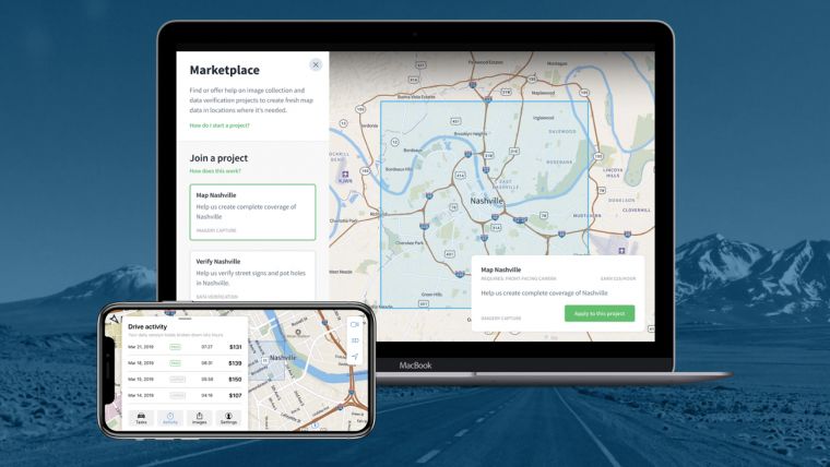
Anyone can browse and complete mapping tasks that have been posted by mapping companies and others on the marketplace. There are several mapping projects live on the marketplace already, with drivers being able to join and complete mapping tasks in Nashville, Dallas, and Gothenburg. All the uploaded images are processed with computer vision which blurs sensitive information like faces and license plates, and the technology automatically detects 43 different object classes before positioning them on the map.
The object classes range from traffic signs and manholes to fire hydrants and utility poles, and there are currently more than 50 billion such street objects that have been detected from the 540 million images on Mapillary’s platform. Mapillary’s collaborative model is unique, as all the images on the platform have been uploaded by people and companies from more than 190 countries across the world.
Solem added “We’re the only organization to publish map data from street-level images in this way, available for anyone with clear usage rights and commercial terms. That’s why people and companies bring images to the Mapillary platform, because they need the data from the imagery and this is the only scalable way for them to access it. Recently we’ve had a lot of companies ask for map data in locations where there is no imagery, and that’s why we’ve built the marketplace.”
Organizations in need of street-level images and map data are able to post mapping requests through the Mapillary web app, where contributors also browse the listing and join projects.

Value staying current with geomatics?
Stay on the map with our expertly curated newsletters.
We provide educational insights, industry updates, and inspiring stories to help you learn, grow, and reach your full potential in your field. Don't miss out - subscribe today and ensure you're always informed, educated, and inspired.
Choose your newsletter(s)


