Maxar Provides NaturalVue and Urban Change Indicator Products to Esri
Maxar Technologies, a global technology innovator powering the new space economy, has announced an agreement to integrate its NaturalVue 2.0 image mosaic and National Urban Change Indicator (NUCI) commercial products into ArcGIS Living Atlas of the World. The operations of DigitalGlobe, SSL and Radiant Solutions were unified under the Maxar brand in February 2019.
ArcGIS Living Atlas of the World is the world's foremost collection of maps developed by Esri partners and the Esri user community and is available in ArcGIS Online, Esri's flagship cloud-based geospatial platform. These enhancements will accelerate the speed at which analysts distill actionable intelligence from multiple sources of geospatial data to solve a variety of problems and missions globally.
NaturalVue 2.0 provides a seamless basemap that reflects the Earth's true colours. The update and improves upon previous versions with enhanced positional accuracy, colour fidelity and spatial resolution. Maxar's image mosaic portfolio also includes Vivid and Metro mosaics, which are the highest resolution global mosaics available commercially. NaturalVue 2.0, Vivid and Metro enable a broad range of geospatial and web-based mapping applications, including military and defence logistics, GIS backdrops, flight simulation, cartographic mapping, 3D visualization and GPS tracking.
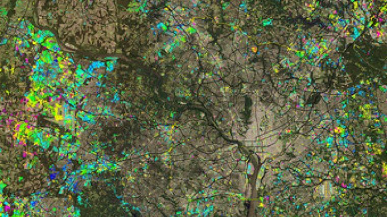
NUCI is Maxar's innovative commercial urban change detection product, which highlights areas of new construction activity by isolating changes that persist over time, derived from over 13,000 Landsat images. NUCI enables analysts to rapidly identify areas of urban expansion across the landscape of the continental United States by filtering out noise from seasonal, agricultural and other natural cycles that hamper traditional image-to-image change detection methods. The dataset includes an archive covering nearly 30-years of change.
"The addition of NaturalVue 2.0 and NUCI to Esri's ArcGIS Online platform gives thousands of GIS professionals the ability to effectively address complex geospatial problems at a global scale," said Tony Frazier, Maxar's executive vice president of global field operations. "Maxar has hundreds of geospatial analysts certified on ArcGIS. The integration of NaturalVue 2.0 and NUCI expands our strong partnership with Esri and furthers our overarching goal to equip our customers with the ability to easily source, enrich and analyse massive amounts of geospatial data to create a decision advantage."

Value staying current with geomatics?
Stay on the map with our expertly curated newsletters.
We provide educational insights, industry updates, and inspiring stories to help you learn, grow, and reach your full potential in your field. Don't miss out - subscribe today and ensure you're always informed, educated, and inspired.
Choose your newsletter(s)


