Nexar Launches Live Map Taking on Google Street View
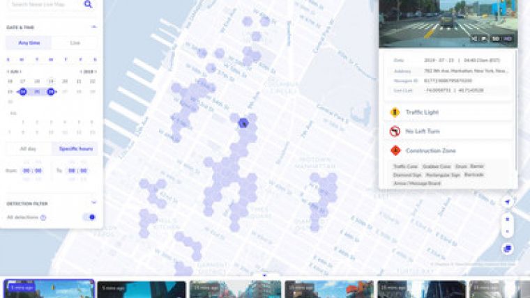
Nexar has announced the launch of Nexar Live Map – a free, online, interactive digital map made of billions of real-time images and metadata from dash cameras in the Nexar network.
Nexar's mission is to eliminate road collisions worldwide by alerting drivers to dangers ahead in real-time. When people pair Nexar's smart dash cams with the Nexar app, they join a connected network of vehicles learning from each other about what's happening on the road. Now that the company's community of drivers is large enough, it has started rolling out these driver alerts that flag upcoming hazards before they get to them.
Nexar Live Map is an important next step in the company's journey because it makes information from its connected vehicle network available to everyone. Live Map uses extremely lightweight artificial intelligence models running on the Nexar smartphone app to pull the most recent images and data from the road. Now, citizens and cities alike can access live insights into things like the most dangerous intersections, road blockages, missing road signs, and more. Nexar is beginning with the launch of Live Map in New York City, and expanding coverage across the United States.
With this launch, Nexar is directly challenging the primacy of Google Street View and the recently launched Apple Maps Look Around feature. Images found on these platforms are months or years old, making them an outdated source of information. Seeing something that happened minutes ago has not been possible until now. The images found on Nexar Live Map are updated constantly, offering the most current frames and information of any mapping tool available.
The images and data found on Nexar Live Map are fully anonymized and aggregated so that neither the driver nor anyone on the road can be identified. Nexar uses advanced AI technology to anonymize faces, license plates, and other potentially private information. No one has access to a Nexar driver's personal data except for that person. Nexar will follow GDPR standards, providing all of its users with strict data protection regardless of lesser local requirements.
"Google Street View pioneered the concept that we can explore the world without getting on a plane. We are proud to innovate in this space by being the first to make it possible to explore the world in real-time using our dash camera network," said Eran Shir, CEO and co-founder of Nexar. "Nexar Live Map is extremely valuable for cities and transit authorities looking to make their roads more efficient, but it's also valuable for citizens. Apartment hunters can avoid neighbourhoods with work zones and loud late-night spots. Drivers challenging a ticket can look back in time to the incident and double-check the road signs. There are so many benefits to being able to explore our cities as they exist today."

Value staying current with geomatics?
Stay on the map with our expertly curated newsletters.
We provide educational insights, industry updates, and inspiring stories to help you learn, grow, and reach your full potential in your field. Don't miss out - subscribe today and ensure you're always informed, educated, and inspired.
Choose your newsletter(s)


