The Revolution of GIS in Map Making
Visualising that what we do not know yet
GIS is crucial for map making nowadays and we could barely imagine cartography without digital data acquisition, processing, analysis and visualisation. But the art of map making is much older than GIS. Ever since the first maps were created thousands of years ago, cartographers have been busy with the collection, processing and careful representation of the world around us – in many output forms and crafted with various tools. How did GIS and data acquisition developments in the 20th century revolutionise this process and, consequently, our use of maps? This article highlights some of the developments we now take for granted, but also changed the world of maps forever.
The production chain of modern maps is all digital in most cases. Data is collected in digital form and stored in a geospatial database, after which datasets are processed, combined and styled before they are graphically represented as a map. Sometimes maps still end up being printed on paper, but many modern maps now remain digital. Think for a moment about the maps you use in daily life. From your car navigation system to a running app on your smartphone and simple maps shown on news websites; digital maps are everywhere. Where maps once were a special and powerful tool only available to the happy few, maps are now a commodity that most people take for granted. How did the world of maps evolve to this point?
Two Separate Worlds
Today, one dataset can have numerous output maps and one map can be made up of numerous datasets. In modern map making, data and representation are two mostly separate worlds. But this has not always been this way. Long before the digital era, maps were also their own database. In case (all copies of) the map got lost, the data the map represented was lost as well – there simply was no spatial database to recreate the same map again. Data was created based on travel experiences, gathering people’s individual knowledge, manual measurements and various types of historical resources. All these sources were combined and brought together in one dataset: the map itself. This required specific creative skills of the mapmaker to interpret and combine the (often subjective) data.
Epidemiology
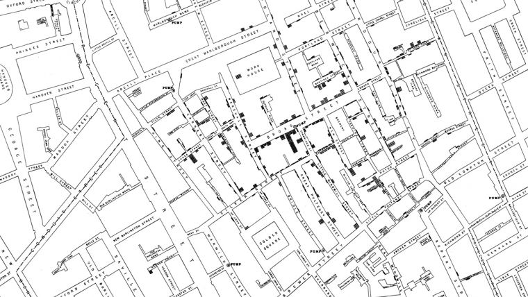
One of the earliest recorded uses of geographical data for analysis was in the 1800s for epidemiology. In 1832 there was a cholera outbreak in Paris, and geographer Charles Picquet was able to identify the source of the disease by marking the location of deaths on a map. They appeared to be clustered around a particular water source. In 1854 a similar analysis was done successfully by John Snow during a cholera outbreak in London. They were the first few GIS users, even though that term was only introduced more than 100 years later.
Objective and Up-to-date
Much has changed since various data acquisition innovations emerged in the 20th century. An important development was the invention of flight, which enabled aerial photography and its use as a source for military map making since World War I. With the innovation in both photography and the aircraft industry it now became possible to regularly fly over a region to capture it, which later also became an important data source for civilian cartography. A similar pivotal development was gaining the capability to put satellites into orbit, such as NASA’s Landsat programme since the 1970s and ESA’s ERS programme in the 1990s. Aerial photographs and satellite imagery could now provide cartographers with objective and up-to-date data sources to create or improve maps. Together with the development of GPS and its commercial use growing since the 1980s, this greatly improved the data acquisition step in map making – and made data acquisition a discipline largely separated from cartography from now on.
Bits on Tape
Despite the rapid technological advancements in aerial photography and the boosting space industry, computers still had very limited memory in the 1960s, which made the development of the first generation of GIS a real challenge. Some technological breakthroughs were required first, such as map scanners and the development of software to represent geographic information as digital bits (to save on tape and later on other media). These developments made it possible to digitise, manipulate and analyse that which was once only available on paper. A new field of expertise was born with people now focusing on the digital storage and analysis of geographic data.
GUI
Another development worth mentioning is the invention of the graphical user interface (GUI) for computers, which made it much easier to perform geographical analysis. While some readers might cherish memories of the earlier command line interfaces, the ease of use of modern desktop or online GIS cannot be denied and it has made GIS more accessible for a large group of users. This greatly improved the possibilities for the visualisation of complex spatial information to various end users in dynamic and, in the internet era, now even interactive maps.
Showing the Unknown
Although we take the existence of GIS for granted today, it has existed only for roughly half a century. The possibilities to combine various data sources digitally and the development of spatial analysis tools radically changed what we can do with geographic information. Spatial relations can be detected that would have been (nearly) impossible to find without the power of a GIS. And such relations can now be visualised in new ways, either static or dynamic, targeted for a specific audience. Where maps once were a way to show that what we already know or can perceive, GIS now enables us to create maps showing that what we do not know yet. This has led to an ever-expanding set of mapping possibilities we still benefit from every day.
This article was published in GIS Professional August 2017

Value staying current with geomatics?
Stay on the map with our expertly curated newsletters.
We provide educational insights, industry updates, and inspiring stories to help you learn, grow, and reach your full potential in your field. Don't miss out - subscribe today and ensure you're always informed, educated, and inspired.
Choose your newsletter(s)


