Vricon Launches 3D Data Product CitySuite
Vricon has announced the launch of CitySuite, a 3D data product to meet the ever-changing demands of the geospatial market. CitySuite is derived from Vricon’s Globe in 3D, which offers users the entire world in highly accurate, immersive 3D. The software package is designed to meet the many and variable demands of 3D geospatial users who require accuracy at a city scale, but need reasonably priced options.
Vricon 3D geodata is being used by emergency responders who want to reduce response times for urban residents. It also can be used by city planners who want to leapfrog aging infrastructures. Insurance companies use 3D imagery to analyse flood patterns, while transportation companies want to enhance efficiencies.
Vricon 3D analytics and data models depict the world the way it really is. It provides data globally based on a multitude areas of interest in a process that uses commercial satellite imagery and big-data analytics to create high-resolution, accurate 3D models without ground control points. Vricon 3D solutions power automated, detailed analysis at scale.
Smart data
“All urban innovation, whether it involves small pilots or larger Smart City initiatives, requires smart data to plan for the best citizen experience,” said Magnus Brege, Vricon CEO. “Vricon CitySuite scales to our users’ needs, from citywide asset management to smart 3D mapping. But unlike other source options, it provides geospatial products that fit with state and local government budgets.”
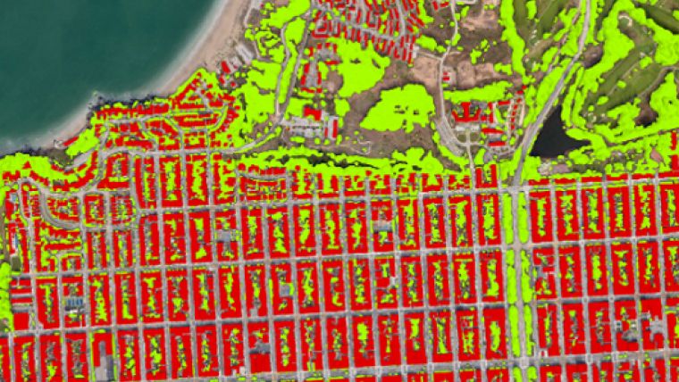
Vricon CitySuite is developed to support planners with a range of activities, from citywide asset management to smart 3D mapping. Derived from our 50cm 3D Surface Model, all Vricon CitySuite products are perfectly aligned and include:
- 2m Digital Terrain Models
- 3D Building Vectors
- 3D Vegetation Vectors
- 4D Bridge Vectors
Vricon uses satellite imagery, patented algorithms, and machine learning to create all the products in their Smart Foundation. Each incorporates a source data accuracy of 1m LE90/CE90 relative, 3m LE90/CE90 absolute. Over 400 U.S. cities are available and the inventory is growing weekly.

Value staying current with geomatics?
Stay on the map with our expertly curated newsletters.
We provide educational insights, industry updates, and inspiring stories to help you learn, grow, and reach your full potential in your field. Don't miss out - subscribe today and ensure you're always informed, educated, and inspired.
Choose your newsletter(s)


