Smart Cadastral Tools for Real Estate Registration
Extensive Use of the INSPIRE GML Cadastral Parcel
The tools, systems and protocols as developed by the Spanish Directorate General for Cadastre are well accepted and widely used. A smart system of coordination between the Cadastre and the Property Rights Registry in Spain is now working and showing results. Agents working in the real estate market are now involved too.
In Spain, the Cadastre and the Property Rights Registry are two separate institutions with differentiated mandates and competences, both working in the domain of land administration. The Spanish Law 13/2015 implements an effective coordination of transactions executed by both institutions. Today the real estate transactions are performed with increased legal certainty. While georeferenced spatial information of parcels is incorporated into the Property Rights Registry, cadastral mapping forms the basis of the graphic representation used. The cadastral data is updated simultaneously with the Property Rights Register.
INSPIRE GML Format
The Cadastre, registries and notaries have worked together to design a technologically advanced model of institutional interaction for this coordination purpose. This model enables the application and use of georeferenced spatial information throughout all real estate transactions. The georeferencing of the parcels, expressed through the INSPIRE GML format of a cadastral parcel, is now widely used by all agents involved in property transactions in Spain. Information is continuously exchanged electronically between citizens, professionals and the various institutions involved. As a consequence, the Cadastre is aware and informed of any alterations to the real estate property recorded in a public deed or in any other object of registration, with a sufficient level of detail to carry out its unattended updating.
Object description
The object present in real estate transactions must be identified at the start of each transaction. This must then be known and agreed upon by all stakeholders. The information derived from the cadastral spatial database is then processed in order to be correctly transcribed into the public transaction document and to be incorporated into the Property Rights Registry. The technical solution developed by the Directorate General for Cadastre allows the list of coordinates as present in the INSPIRE GML format to be linked with its graphic visualisation without the need for specialised GIS tools.
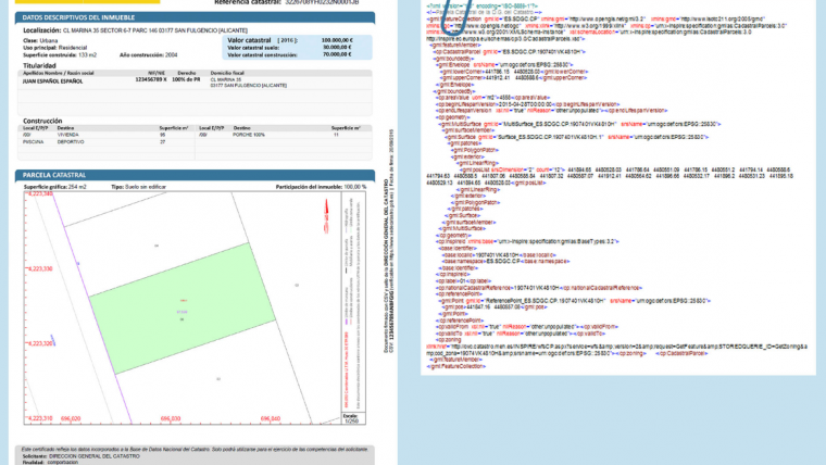
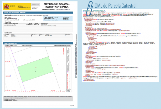
The cadastral cartography, and in particular the ‘descriptive cadastral and graphic certification’, has been chosen as the instrument to achieve the correct graphic description of the registered properties. This guarantees the coherence of the graphic information that is registered, ensures that there are no overlaps on neighbouring parcels or on neighbouring public land, and guarantees the graphic coordination with the Cadastre. The certified graphic information of the cadastral parcel is expressed in the INSPIRE GML cadastral parcel format (see Figure 1).
Representation of physical reality
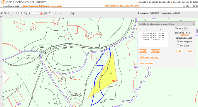
In cases where the cadastral cartography does not sufficiently reflect the physical reality, procedures have been defined for updating the graphic data of the parcel involved through the use of alternative georeferenced graphic representations. These alternative representations are expressed again in the INSPIRE GML Cadastral Parcel format and can be generated from various computer applications. A simple internet search shows the plethora of tools available, appearing as free and open software tools, tools provided by professional institutions as well as tools from specialised commercial firms. Other options include free plug-ins for AutoCAD, QGIS or gvSIG as well as the tools presented on the Cadastre’s website (see Figure 2).
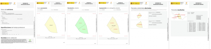
Validation
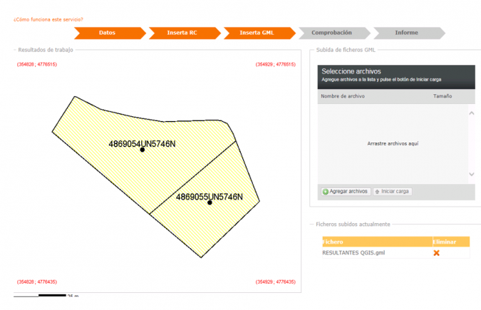
An alternative graphic representation must comply with certain technical conditions established in the relevant development resolutions. It must be represented in the cadastral cartography and the delimitation that already exists in the cadastral cartography must be respected. The accreditation of these conditions is verified by means of the ’validation service of alternative georeferenced graphical representations’ on the Cadastre’s website, (see Figure 3). This results in the ‘graphic validation report’ as shown in Figure 4.
Latent demand
The key parts of the technical solution, the cadastral certification and the graphic validation report of the new, alternative georeferenced representation, can be obtained via a web service by citizens and professional users from the Cadastre’s website.
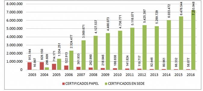
Over the course of 2016, more than seven million certificates and fifty thousand reports were issued, practically all of them electronically. Beyond the substitution effect of the face-to-face channel by the online channel, this shows the clear and ongoing emergence of a latent demand for cadastral information. Between the implementation of the Cadastre’s website in 2003 and today, the number of cadastral certificates issued has multiplied by seven, and last year saw an increase of more than 10 percent (see Figure 5). It must be emphasised that only 15 percent of certificates are obtained by private citizens. The other 85 percent are being directly obtained by professional users – the notaries, registrars and authorities that need them. These are obtained not only interactively, but also by utilising the electronic web-based services enabling automatic data exchange between the information systems.
Authentic documents
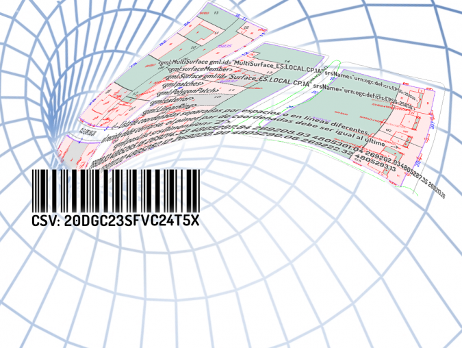
The INSPIRE GML of the graphic situation of the cadastral parcel as certified by the Directorate General for Cadastre is embedded in the cadastral certification and the graphic validation report. The Directorate ensures the authenticity and integrity of its contents. This circumstance is achieved thanks to the fact that both products are electronic documents, signed using a secure 16-digit verification code. This code unequivocally identifies the document in the Directorate General for Cadastre’s catalogue. The exchange between the various stakeholders requires only the 16-digit barcodes (see Figure 6). This avoids the need to physically exchange computer files, allows the visualisation of the new representation without GIS tools and enables the automated capture of its contents, thus preventing possible transcription errors.
Concluding remarks
The introduction of this system has enabled strong progress in the coordination between the Cadastre and the Property Rights Registry. The system contributes to standardising the internal processes of all the stakeholders involved in the real estate sector. Interoperability between stakeholders’ systems is enhanced and at the same time administrative procedures are simplified, costs are reduced and legal security is increased. Cadastral data has been incorporated and has been marked as coordinated in the Property Rights Registry, and the data related to delimitation, location and area is considered to be true for all legal purposes. This promotes transparency in real estate transactions by establishing an adequate procedure for generating spatial descriptions of real estate objects. This is principally based on cadastral cartography, and allows citizen participation by offering access for citizens to rectify and/or update the real estate object’s description.
Watch here a video showing how the various tools work.

Value staying current with geomatics?
Stay on the map with our expertly curated newsletters.
We provide educational insights, industry updates, and inspiring stories to help you learn, grow, and reach your full potential in your field. Don't miss out - subscribe today and ensure you're always informed, educated, and inspired.
Choose your newsletter(s)


