SphereVision Launches Complete 360 Imaging Platform
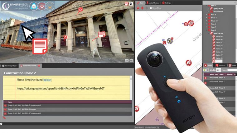
SphereVision is revolutionising the use of 360 degree imaging with the release of SphereVision Project. An intuitive end to end solution, the suite is designed to bring together 360 degree imagery with site specific information such as still photography, documents and maps. Complete with a modularised project builder and easily distributable viewers, the desktop software suite includes three brand new modules; Virtual Reality, Geospatial and Timelapse Capture. SphereVision Project also includes a range of other new features and functionality including an automatic 360 tour generator.
“SphereVision Project, unlike other solutions that tend to be ‘service led’, allows users to create their own 360 imaging solution,” said Jonathan Bolton, Product and Service Manager at SphereVision. “The new modules provide flexibility together with advanced functionality and integration options. Completed projects are easily distributed at the desktop, online or in VR.”
SphereVision Project harnesses the power of virtual reality utilising the HTC Vive headset. Users can experience remote sites, immersing themselves in full 360 imagery, and access embedded document and media files. It can also be distributed through standalone VR viewers, enabling clients to utilise this technology for presentations, site familiarisation and health and safety briefs.
Real world context can be added to SphereVision projects with the use of georeferenced images, such as aerial photography, or maps. SphereVision Geospatial allows users to import GeoTIFF files or link directly to OpenStreetMap data using intuitive workflows. Geospatial metadata, from many mobile and static mapping location based services, can be automatically extracted ready to spatially reference new SphereVision projects.
SphereVision Timelapse allows for the display of multiple 360 captures across a project timeline. Images can be easily combined into a single media type and different epochs navigated to compare project progress, site condition or feature location through time. A comparison image slider further enhances functionality allowing projects to be ‘rolled back’ or ‘scrolled forward’.
Additional functionality on offer from SphereVision Project includes smoke layers, media filters, a user defined layer system and iconography, HDR capability, video hotspots, media links and PDF integration.

Value staying current with geomatics?
Stay on the map with our expertly curated newsletters.
We provide educational insights, industry updates, and inspiring stories to help you learn, grow, and reach your full potential in your field. Don't miss out - subscribe today and ensure you're always informed, educated, and inspired.
Choose your newsletter(s)


