Survey on Pan-European Gazetteer Services
To explore interest in developing a pan-European gazetteer service, the Joint Research Centre of the European Commission (JRC) and EuroGeographics, the member organisation for European National Mapping and Cadastral Agencies, have commissioned an open stakeholder survey. You can access the survey and distribute it to others via this link: https://ec.europa.eu/eusurvey/runner/EUGazetteerSurvey. Submission of answers is possible until 3 November 2017.
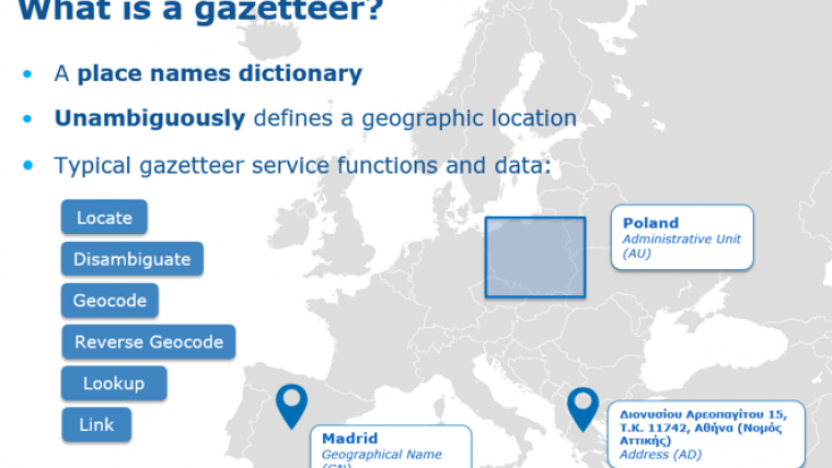
Key ‘high value’ datasets, such as geographical names and addresses, have many uses both inside and outside the public sector. They form the backbone of European location services, which may include ‘gazetteer’ services, linking place names and addresses to point and area locations. These datasets are often used in conjunction with other ‘high value’ data themes, such as land parcels, hydrography and transport networks.
Targeting both data providers and data users, the survey aims to understand the extent to which access to pan-European complete, open and free location datasets and services, like these, will create new opportunities for data users and application developers beyond those already available nationally. It also aims to understand the situations where ‘official’ data is needed, where ‘community-sourced’ data may be applicable, and where such data may be sourced.
The JRC is undertaking this survey as part of the five-year European Location Interoperability Solutions for e-Government (ELISE) action, which is supported by the ISA² programme. The results will be used to implement relevant gazetteer solutions, starting with a pilot informed by the survey.
EuroGeographics is undertaking this activity as part of the Open European Location Services (Open ELS) project, which is developing pan-European data services using authoritative geospatial information. Open ELS is a two-year project co-financed by the European Union's Connecting Europe Facility. The survey’s results will be used to develop its pan-European Open ELS services.

Value staying current with geomatics?
Stay on the map with our expertly curated newsletters.
We provide educational insights, industry updates, and inspiring stories to help you learn, grow, and reach your full potential in your field. Don't miss out - subscribe today and ensure you're always informed, educated, and inspired.
Choose your newsletter(s)


