Telefónica and Samsung Utilize LuxCarta Advanced Geodata
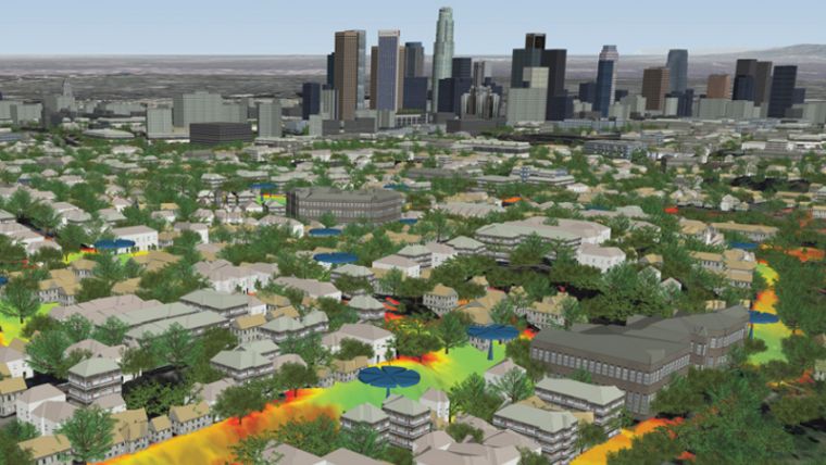
LuxCarta, a provider of geodata to the wireless ecosystem, has announced it is providing specialized geodata designed for use with RF planning simulations at high frequencies to Telefónica Deutschland and Samsung for their first 26GHz tests in Hamburg. LuxCarta is providing 2m resolution City Planner building models, along with specialized vegetation layers, terrain and clutter for the Hamburg city centre and another suburban test area.
“5G networks that utilize mmWave frequencies require more precise geodata for RF simulation planning than any previous generation of network technology,” said Thomas Riedel, head of Samsung Networks Europe. “By using LuxCarta’s specialized geodata – including individual trees – we are able to model the performance of our equipment prior to its deployment and on-air testing with Telefónica.”
Millimetre wave (mmWave, e. g. 26-28GHz) frequencies are being considered in trials and preliminary network implementations of 5G networks around the world. Unlike traditional wireless networks utilizing frequencies less than 2.6GHz, mmWave frequencies are substantially impacted when they encounter obstructions. For this reason, it is necessary to account for each individual tree when creating the RF plan with these high frequencies.
LuxCarta has been the preeminent producer of high-resolution 3D building data in support of RF engineering for many years. The company has also innovated in the creation of new types of geodata, including 2.5D clutter heights, population maps and 3D tree models for 5G.

Value staying current with geomatics?
Stay on the map with our expertly curated newsletters.
We provide educational insights, industry updates, and inspiring stories to help you learn, grow, and reach your full potential in your field. Don't miss out - subscribe today and ensure you're always informed, educated, and inspired.
Choose your newsletter(s)


