TerraGo Edge 4 Delivers New Mobile Features
The TerraGo Edge has undergone a complete redesign improving the user experience to help get work done faster, easier and more efficiently.
The redesign marks the availability of TerraGo Edge version 4.0, which also offers field user observations and task-centred design cycles, as well as a host of new features including the addition of Google and Apple basemaps.
“The new interface is so much more than just a “look and feel” change; it will allow us to more efficiently execute projects and improve data quality in less taps and less time, which is a force multiplier when you’re talking about thousands of data points per day.” said Scott Riccardella, Director Oil and Gas Business Development, Structural Integrity Associates. “Having the right tool is essential to getting any job done right; and TerraGo is ahead of the game when it comes to giving my field teams the best possible tool for the fastest, most accurate and highest-quality asset inspections.”
“We have completely rebuilt the mobile user interface from the ground up to improve all aspects of the app’s performance, and while users will notice the stunning graphics and aesthetics, the real value is that the feature or data you need is always just one tap away,” said Dave Basil, Vice President of Product Development at TerraGo. “By incorporating the latest native design elements like tabbed navigation, responsive split screens and adaptive list views, we found ways to improve the speed and efficiency of the work our customers do every day.”
Register now for the webinar on Tuesday 9th May 2017 at 12:00 PM EDT, to see TerraGo Edge’s latest features, including:
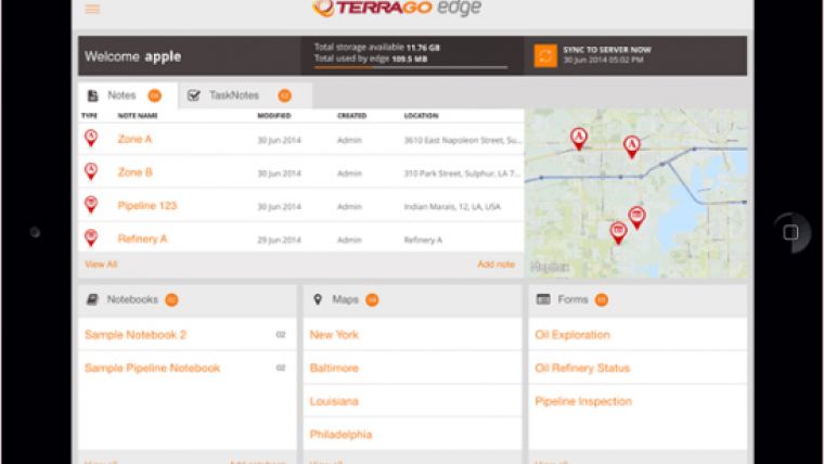
- Reimagined User Experience: We have completely rebuilt the Edge mobile user interface incorporating both years of user feedback from the field and interactive design cycles with live users.
- Google and Apple maps: Standard, satellite and hybrid maps are available for data collection and are paired with new precise location pin icons for a cutting edge data collection experience.
- Tabbed App Navigation: With the new, easier to reach tabbed navigation, it’s easier than ever to collect data in the field. You are always one tap away from the data or feature you need to do your job.
- Quick Capture Button: Allows you to create notes, complete forms, take photos, drop points and draw lines/polygons from virtually anywhere in the app, with only one tap.
- Unlimited Attachments: Now you can attach as many forms, photos or videos as you would like to a single note. No more having to choose between multiple forms, documents or media attachments.
- Responsive Split Screen View: When holding your tablet or larger mobile device in landscape mode, new split screens will automatically allow you to view lists/maps or lists/details all on one screen.
- Detailed List View: The new detailed list view shows more of your important note data making it easier than ever to find the notes you’re looking for and enables one-tap actions directly from the list.
- One-Tap Forms and Maps Lists: Now you can view all your form templates, and instantly create notes using them, or view all your offline maps and directly access them, from one master list.
- Precise Location: Capture a more accurate location when creating notes by using the center crosshair target and coordinate level accuracy for dropping points and drawing lines/polygons.
- Filter by Map Extent: This new feature keeps the notes on your map and in your list dynamically in sync, just one more way to make it easier to navigate an area of interest and find the notes you need.
- Quick Basemap Preview: Preview your online and offline basemaps in real-time from the selection screen to easily choose the map you’re looking for with one tap and no toggling back & forth.
- Arc2Edge Plug-in: ArcGIS Desktop users can directly share maps and features with mobile users, allowing them to roundtrip updates and new features from the field back to ArcGIS.
Try the TerraGo Edge 4 iOS or Android app for free.

Value staying current with geomatics?
Stay on the map with our expertly curated newsletters.
We provide educational insights, industry updates, and inspiring stories to help you learn, grow, and reach your full potential in your field. Don't miss out - subscribe today and ensure you're always informed, educated, and inspired.
Choose your newsletter(s)


