ArcHeritage Reveal National Trust Hidden Treasures
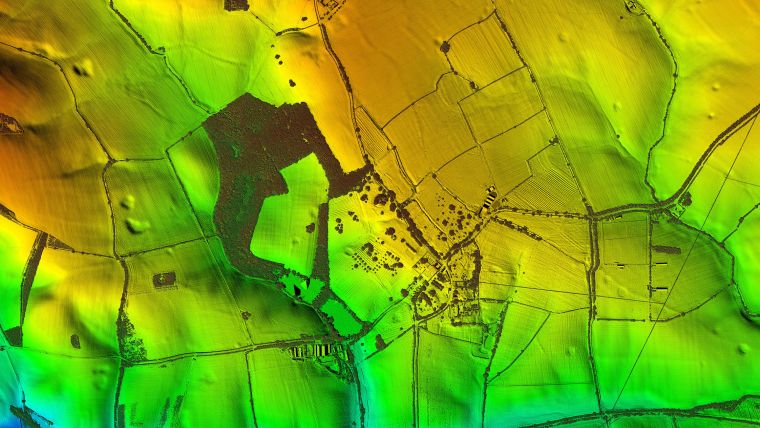
3D maps created from aircraft mounted lasers are helping the National Trust uncover secrets at the historic Canons Ashby estate in Northamptonshire, UK. Working with archaeological and heritage practice ArcHeritage, Bluesky has completed a Lidar survey of 690 hectares, around and including the estate. From the millions of individual laser measurements collected, Bluesky created high resolution 3D models of the bare earth surface (Digital Terrain Model / DTM) and of its surface features, including building and trees (Digital Surface Model / DSM).
Analysis of the models has already uncovered evidence of more than 300 potential archaeological features within the survey area, whilst comparison with aerial photographs, dating back to the 1940s, is helping to identify more recent features and activities. According to Anna Badcock, director of ArcHeritage, the data has already led to discoveries at other National Trust landscapes, and she is confident that the data will add to and enrich the story of the Canons Ashby landscape.
Geospatial Information Supporting Views
The Lidar data is also being used by ArcHeritage to create a Zone of Theoretical Visibility (ZTV); a computer generated tool that helps to identify the setting of Canons Ashby. The ZTV will help the National Trust understand the potential extent of views from Canons Ashby House, providing a useful tool for making decisions based on the visual impact of future landscape changes.
Canons Ashby, named after the Black Canons who founded the Augustinian Priory in the twelfth century and the medieval word for farmstead ‘ashby’, has been owned by the National Trust since 1981. Famous for its Tudor manor house, incorporating the priory remains as well as terraced gardens, the house and gardens have survived largely unaltered since the 1700s. Canons Ashby is a Scheduled Monument, comprising the remains of the medieval monastery, castle settlement and fields, post medieval houses, gardens and parklands, and is located within a Conservation Area and Grade II Registered Park and Garden.

Value staying current with geomatics?
Stay on the map with our expertly curated newsletters.
We provide educational insights, industry updates, and inspiring stories to help you learn, grow, and reach your full potential in your field. Don't miss out - subscribe today and ensure you're always informed, educated, and inspired.
Choose your newsletter(s)


