Imajing Provides Esri Users with Online 3D-enabled Images
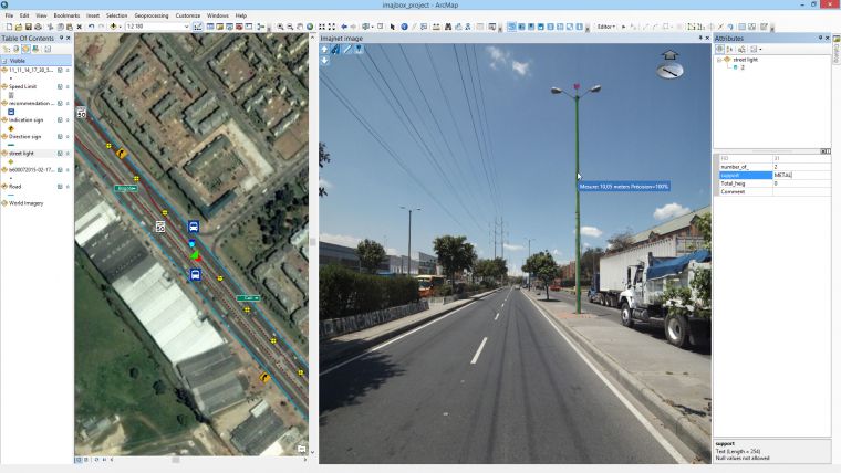
Developed by Imajing, Imajnet enables transportation infrastructure managers to host and share, within their organisation, georeferenced 3D images surveyed with the Imajbox mobile mapping system. Imajing has developed extensions to enable Imajnet integration in ArcMap with a plug-in and ArcGis Online with a widget.
Hosted in the Imajing cloud or deployed on public organisation servers, Imajnet provides common references and data for field teams, engineering and management professionals to facilitate the recurrent monitoring of transportation networks.
Full interaction
The web service integrates a set of tools enabling users to inventory and measure equipment visible in images, process and overlap GIS layers, navigate in surveys history, and search for places in geographical or linear coordinates. Recognised as a concrete solution to manage nationwide networks, Imajnet enables a full interaction between Esri environment and 3D images collected by Imajbox mobile mapping system.
Imajing provides a dedicated plug-in for an integration in ArcMap, and a dedicated widget for an integration in ArcGis Online. All Esri users working with surveys performed by Imajbox mobile mapping system will be able to centralise data on the same application, and give life to their Esri suite.

Value staying current with geomatics?
Stay on the map with our expertly curated newsletters.
We provide educational insights, industry updates, and inspiring stories to help you learn, grow, and reach your full potential in your field. Don't miss out - subscribe today and ensure you're always informed, educated, and inspired.
Choose your newsletter(s)


