New Version of MapThat Released
Cadline’s DynamicMaps team is pleased to announce the release of MapThat version 2.1.0. This new version has updates to the Data Table, Scale Print Tool, Drawing Tools, Measure Tool and the Spatial Importer Tool, as well as increased PostGIS interoperability.
We have also implemented a new Data Table Export to GIS option, an OpenStreetMap Search Tool and Data Layer Search Tool. This latest version is now available to trial using our TryMapThat website.
MapThat version 2.1.0 now has the following enhancements:
- Open Street Map Search tool has been added, allowing users to search for any UK Place or Street Name
- Scale Printing now allows the user to print to Current Scale
- Scale Printing tool has been updated to show users only their specific Print Jobs, as well as only them to choose their specific Print Templates
- Scale Printing will now intuitively only print the records that a user has either filtered using the Data Table or selected using the Area Search tool
- Data Table now has options to export All or Filtered records to Excel or GIS file
- Data Table width has also been widened to make the Layer Name and Filter boxes wider
- Data Table now has a Clear Layer button to more easily remove a Data Layer from the map and a Show All Records button to allow users to view all the records for a chosen Data Layer
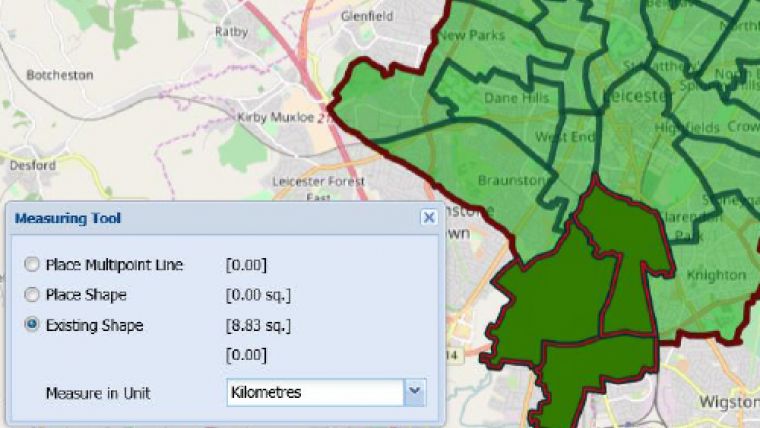
- Measure Tool will now automatically calculate areas for multiple polygons
- MiniMap Overview Window can now either show or hide Data Layers
- Map Coordinates and Scale Bar can now be auto hidden
- Drawing Tools now have a new option to Draw Circles Manually within the map
- Sketch Layer list can be controlled by the Admin User to show only the last X number of Sketch Layers or ones that have been updated since a specific date
- Data Layers Search Tool has been added which allows users to type a name of any layer and easily find its location either in the current or any other Project
- Spatial Importer Tool has been updated to import from and export to AutoCAD DXF format
- WMS Layers can now be rendered as either One Image or Tiled
- Thematic Legends can more easily be shown and auto hidden as required
- PostGIS compatibility with MultiPolygons, 3D Geometry and tables with missing geometry

Value staying current with geomatics?
Stay on the map with our expertly curated newsletters.
We provide educational insights, industry updates, and inspiring stories to help you learn, grow, and reach your full potential in your field. Don't miss out - subscribe today and ensure you're always informed, educated, and inspired.
Choose your newsletter(s)


