Standard to Improve the Way Information Is Referenced to the Earth
The Open Geospatial Consortium (OGC) has approved the Discrete Global Grid System (DGGS) as OGC Abstract Specification - Topic 21 [OGC 15-104r5]. The goal of DGGS is to enable rapid assembly of spatial data without the difficulties of working with projected coordinate reference systems. The OGC DGGS Abstract Specification standard defines the conceptual model and a set of rules for building highly efficient architectures for spatial data storage, integration and analytics.
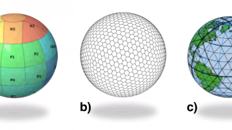
DGGSs represent the Earth as hierarchical sequences of equal area tessellations on the surface of the Earth, each with global coverage and with progressively finer spatial resolution. Individual observations can be assigned to a cell corresponding to both the position and size of the phenomenon being observed. DGGS come with a standard set of functional algorithms that enable rapid data analysis of very large numbers of cells and, by their very nature, are well suited to parallel processing applications at multiple spatial resolutions.
DGGS will provide the capability to properly integrate global geospatial, social, and economic information. It also allows communities with data attributed to fundamentally different geographies to integrate this information in a single consistent framework, according to Dr Stuart Minchin, chief, Environmental Geoscience Division at Geoscience Australia.
Overcoming Raster-Vector Divide
DGGS will revolutionise the way we perceive, work with, and visualise spatial information, according to Dr. Matthew Purss, senior advisor at Geoscience Australia, co-chair of the OGC DGGS Standards and Domain Working Groups, and Editor of the OGC DGGS Abstract Specification – Topic 21 [OGC 15-104r5]. DGGS are a technology that allow the harmonisation of raster, vector, and point cloud data in a common, globally consistent framework – enabling the spatial industry to overcome some key challenges presented by traditional GIS approaches; namely, the ‘raster-vector divide’, as well as the use of map projections.
Dr Zoheir Sabeur, Science Director at University of Southampton IT Innovation Centre, United Kingdom, and co-chair of the OGC DGGS Standards and Domain Working Groups, expects DGGS to become the de facto standard grid referencing system globally for geographic Big Data. DGGS will fit in the stack of big data necessary for intelligent processing levels that will enable fast and accurate exploration, mining, and visualisation of Big Data.
Growth in Geospatial Data Volume and Variety
There is explosive growth in both the variety and the volume of spatial data and processing resources, along with a growing understanding of the tremendous benefit that can be derived from enabling interoperability between them. On the other side of this deluge of spatial content is a growing demand by decision-makers for a participatory environment where content can be accessed directly from diverse contributors and used with other content without reliance on time-consuming and costly geographic transformation processes.
One of the core contributions of a DGGS is geospatial data fusion on demand. In a multiple provider environment, fusion is only possible with an information system architecture based upon open standards. The OGC DGGS Abstract Specification provides a platform to enable interoperability within and between different DGGS implementations while promoting reusability, knowledge exchange, and choices in the design of individual DGGS implementations.
As with any OGC standard, the open DGGS Abstract Specification is free to implement.

Value staying current with geomatics?
Stay on the map with our expertly curated newsletters.
We provide educational insights, industry updates, and inspiring stories to help you learn, grow, and reach your full potential in your field. Don't miss out - subscribe today and ensure you're always informed, educated, and inspired.
Choose your newsletter(s)