Urs Hugentobler
Urs Hugentobler is a professor of Satellite Geodesy and heads the Satellite Geodesy Research Facility of the Technical University of Munich, which operates the Geodetic Observatory Wettzell together with the...

Urs Hugentobler is a professor of Satellite Geodesy and heads the Satellite Geodesy Research Facility of the Technical University of Munich, which operates the Geodetic Observatory Wettzell together with the...

Roland Pail is a professor of Astronomical and Physical Geodesy at the Technical University of Munich. His research activities focus on global and regional modelling of the Earth’s gravity field,...

Global reference systems such as the International Terrestrial Reference Frame provide the foundation for determining positions on Earth and in space, as well as for reliably quantifying our planet’s changes...

1Spatial has successfully secured a three-year contract with a leading distribution system operator for electricity and gas networks in Belgium. The contract, awarded after a competitive tender process, will involve...
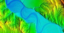
Woolpert has secured a contract with the University of Wyoming to generate a digital terrain model and contours. Leveraging Lidar data previously acquired for the United States Geological Survey (USGS),...

Lidaretto is flexible and compact Lidar scanning system developed since 2015 and uniquely designed to be used the way that fits best to users’ specific application. You can easily mount...

The EAASI Summit 2023 in Lisbon in November was a resounding success. While the aerial surveying association’s fifth annual gathering highlighted the growing unity within the industry, there was also...

Maxar Intelligence has been awarded a contract to supply the National Geospatial-Intelligence Agency (NGA) with a Precision3D Data Suite bundle. This comprehensive package covers an extensive area of 160,000 square...

Olga Bjelotomić Oršulić is an assistant professor in the Department for Geodesy and Geomatics at the University North, Croatia. Her interests include physical geodesy, geoid determination, remote sensing, tectonic movement...

Over the past 20 years, various initiatives have been launched reflecting the importance of cadastral data for land management and spatial development. But how have these initiatives enhanced the possibility...
This site uses cookies. By continuing to use this website, you agree to our Cookies Policy. Agree