Lidaretto
Lidaretto is flexible and compact Lidar scanning system developed since 2015 and uniquely designed to be used the way that fits best to users’ specific application. You can easily mount...

Lidaretto is flexible and compact Lidar scanning system developed since 2015 and uniquely designed to be used the way that fits best to users’ specific application. You can easily mount...
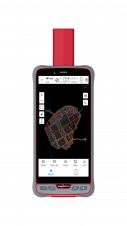
ComNav Technology has introduced its new handheld P6H. This advanced and rugged device is tailor-made for GIS data collection and outdoor operations. Featuring a GNSS high-precision positioning module, rugged IP67-rated...

GrabMaps is preparing to launch KartaCam 2, a crowdsourced mapping solution combining high-end imagery and AI capabilities to transform local expertise into effective navigation solutions. With the introduction of enhanced...

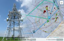
ESA has launched a call for proposals to demonstrate the capabilities of new 5G cellular networks to support positioning and timing applications to complement satellite navigation, just as today’s smartphones...
The development of fifth-generation wireless technology (5G) is spreading rapidly around the world. The initial improvement of up to 10x in speed and 400x in latency, as well as a...

Over the past 20 years, various initiatives have been launched reflecting the importance of cadastral data for land management and spatial development. But how have these initiatives enhanced the possibility...

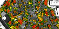
Land Info Worldwide has assembled a team of renowned geospatial companies to help plan the roll-out of 5G networks across Europe. Land Info is already the premier provider of mapping...
Land Info Worldwide Mapping LLC has been named to the 2019 Inc. 5000 list of fastest-growing private companies in the United States. The firm credits its explosive three-year revenue growth...
3D digital models derived from high-resolution aerial photography are helping network operators plan the rollout of services including WISP (Fixed Wireless Access), 5G and Smart City applications. The work by...

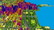
NTT DATA, an IT services provider, has announced the launch of AW3D Telecom for 5G, an advanced 3D digital map package that leverages high-quality satellite imagery for the planning of...
This site uses cookies. By continuing to use this website, you agree to our Cookies Policy. Agree