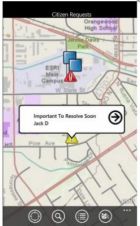
More Intuitive ArcGIS for iOS
Esri has released an updated version of ArcGIS for iOS that includes several enhancements, as well as support for pop-up windows, access to ArcGIS Online basemaps, and new collaboration features....
Esri has released an updated version of ArcGIS for iOS that includes several enhancements, as well as support for pop-up windows, access to ArcGIS Online basemaps, and new collaboration features....
PCI Geomatics, Canada, is collaborating with MDA Geospatial Services to implement operational software tools for ArcGIS using RADARSAT-2 demonstration data. PCI introduced GeoImaging Tools for ArcGIS in 2010, and is...
Microsoft Windows Phone users can access sophisticated mapping capabilities on their phone with the ArcGIS for Windows Phone app. ArcGIS for Windows Phone lets you find, use, and share maps...
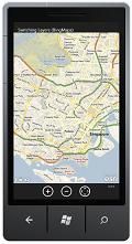
Esri has released a mobile geographic information system (GIS) API for the new Microsoft Windows Phone platform. The ArcGIS API for Windows Phone can be used to create interactive applications...
The recently-released ERDAS Extensions for ArcGIS 10 consists of Image Analysis for ArcGIS, Stereo Analyst for ArcGIS, and two optional modules that extend Stereo Analyst functionality, ERDAS Terrain Editor for...
The new version of ArcGIS Explorer, a free geographic information system (GIS) viewer, opens more avenues for users to share geographic information. It also has new interoperability updates that help...
Esri is offering a free, one-day seminar, Increase Productivity with ArcGIS 10, that will benefit professionals in all industries, whether they are working in a desktop, mobile, server, or cloud...
Tractbuilder has adapted Tractbuilder Tools for ArcGIS 10. The software is still compatible with 9.3 and 9.3.1. "Our development and testing staff have been working very hard to ensure a...
ArcGIS Desktop users can now easily and quickly add demographic reports and data for the United States to their geographic information system (GIS) projects with Esri Business Analyst Online (BAO)...
Esri announces that the Consultative Group on International Agricultural Research (CGIAR) has signed a site license providing its fifteen research centres throughout the world with access to ArcGIS software. CGIAR...
This site uses cookies. By continuing to use this website, you agree to our Cookies Policy. Agree