Moritz Lauwiner
Moritz Lauwiner is executive vice president and president of the Geomatics division at Hexagon’s Geosystems division. In this role, he oversees research and development, business strategy and overall management of...

Moritz Lauwiner is executive vice president and president of the Geomatics division at Hexagon’s Geosystems division. In this role, he oversees research and development, business strategy and overall management of...

Looking for a recipe for business success in surveying? Don't underestimate the importance of innovative surveying services, says Moritz Lauwiner. The latest measurement sensors and software, decades of collective experience...

The fourth edition of Geo Connect Asia (GCA), celebrated as the region's premier trade event and conference for the geospatial, positioning and remote sensing industries, truly delivered during its two-day...
SimActive has reported that the use of its Correlator3D product along with ground control points can enhance, extend and validate photogrammetry projects. GCPs are critical in photogrammetry projects, but there...

The Open Maps For Europe 2 (OME2) project has revealed plans to boost the utilization of European cadastral data. This includes efforts to enhance its discoverability and accessibility. As part...

EuroGeographics is drawing attention to the indispensable role of official national geospatial data in enhancing Copernicus Services, particularly within land monitoring and emergency management. This highlights a reinforced partnership between...

Despite some uncertainty, there is renewed interest in drones, and remote sensing technologies are being embraced by smaller survey companies. Read these and other findings from our annual industry survey!...

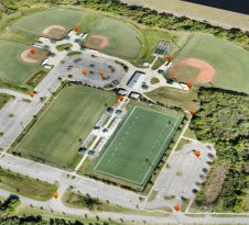
The University of Nacional Autónoma de México (UNAM) has recently procured a RIEGL VQ-1560 II-S airborne system through its Institute of Geography. It has been added to the R&D project...

Dedicated to the world’s tomorrow, Trimble is a technology company delivering solutions that enable our customers to work in new ways to measure, build, grow and move goods for a...
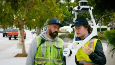
Join Noah Eckhous from NavVis and Mike Walle from Denn Engineers in downtown Culver City to explore how SLAM-based data capture technology transforms topographic survey workflows. In this video, we...
This site uses cookies. By continuing to use this website, you agree to our Cookies Policy. Agree