SDG 11 as a ‘Glocal’ Framework
In urban planning, there is a case for stronger connections between global and local (‘glocal’) issues, strategies and actions. How can the Sustainable Development Goals (SDGs) help local governments to...

In urban planning, there is a case for stronger connections between global and local (‘glocal’) issues, strategies and actions. How can the Sustainable Development Goals (SDGs) help local governments to...
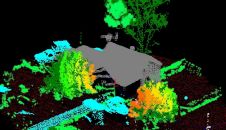
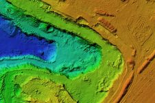
The arrival of unmanned aerial vehicles (UAVs or ‘drones’) has democratized the Lidar market forever. Everyday projects can be flown easier and faster, and sensors are getting lighter, more accurate...
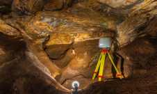
TLS and SfM photogrammetry have been used for the geodetic surveying and 3D mapping of the Ochtiná Aragonite Cave in Slovakia. This world-famous karst landscape of significant geological, geomorphological and...
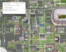
Oklahoma State University (OSU) in the USA has become the latest higher education institution to launch on Concept3D's robust interactive map and virtual tour platform. It brings OSU’s nearly 1,500-acre...

A new basemap combines 360-degree aerial imagery and precise location data, providing an immersive new way to view and experience the built world from every cardinal direction. Basemap imagery offerings...

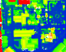
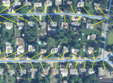
In orthophoto projects of dense urban areas, true orthophotos are preferred over traditional orthophotos because they put building roofs into the correct horizontal position. However, there is still a widespread...
DJI recently introduced the P4 multispectral, a high-precision unmanned aerial vehicle (UAV or ‘drone’) which exploits the integration of multispectral cameras to facilitate agricultural and environmental monitoring applications. Therefore, imagery...
As geospatial professionals, we pride ourselves on being led by objective data that we can verify and trust. But like all humans, even we are not immune to bias, according to...
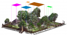
Whether as 2D drawings or 3D point clouds, digital cultural heritage is becoming the norm in heritage documentation nowadays. However, raw digital data still requires manual labelling in order to...
For most of us, it is hard to imagine how we would function without an address, yet many people still do not have this basic identity. To those of us...
This site uses cookies. By continuing to use this website, you agree to our Cookies Policy. Agree