JOUAV unveils advanced airborne Lidar sensor
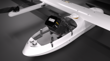
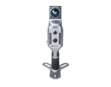
JOUAV has released the JoLiDAR-1000 Lidar sensor designed specifically for uncrewed aerial vehicles (UAVs or ‘drones’) as the latest addition to its array of high-performance Lidar sensors for use in...
JOUAV has released the JoLiDAR-1000 Lidar sensor designed specifically for uncrewed aerial vehicles (UAVs or ‘drones’) as the latest addition to its array of high-performance Lidar sensors for use in...

Mosaic has partnered with Movella aimed at redefining precision and efficiency in mapping and 3D reconstruction projects. Mosaic is specialized in mobile mapping camera systems, while Movella is a renowned...

Visitor registration is now open for GEO Business, the UK's largest geospatial event. The free-to-attend expo, tailored for geospatial professionals seeking to harness the potential of location intelligence, will return...
Trimble has unveiled the integration of the Trimble Applanix POSPac Cloud post-processed kinematic (PPK) GNSS positioning service, featuring CenterPoint RTX, with the UAV-based mapping and data collection capabilities of DroneDeploy’s reality...
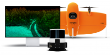
Wingtra has unveiled its innovative Lidar-drone solution. The new Lidar payload is designed to seamlessly integrate the efficiency, ease of operation, and high accuracy of the WingtraOne GEN II drones...
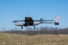
In a new strategic partnership, Inertial Labs' RESEPI Payload Lidar technology will be integrated into E38's advanced E455 drone platform. This collaboration marks a significant milestone in the utilization of...
Stonex has launched a new SLAM solution for fast and efficient large-area surveys: the X70GO SLAM laser scanner. It combines mobile scanning with a stationary mode to scan with higher...

Stonex is an Italian company, world leader in measurement and surveying. The head office is near Milan and the American headquarters is in Concord, USA. The company also has a...

Urs Hugentobler is a professor of Satellite Geodesy and heads the Satellite Geodesy Research Facility of the Technical University of Munich, which operates the Geodetic Observatory Wettzell together with the...

Global reference systems such as the International Terrestrial Reference Frame provide the foundation for determining positions on Earth and in space, as well as for reliably quantifying our planet’s changes...
This site uses cookies. By continuing to use this website, you agree to our Cookies Policy. Agree