NavVis Launches IndoorViewer 2.4
NavVis has announed that version 2.4 of their IndoorViewer software is now available. This major release includes a number of relevant updates that will increase the possibilities of the 3D...
NavVis has announed that version 2.4 of their IndoorViewer software is now available. This major release includes a number of relevant updates that will increase the possibilities of the 3D...
NavVis has announced it has added EUR25 million of fresh funding to fulfil its mission to digitize commercial buildings and assets. The funding complements the German mobile mapping system company’s...
NavVis has launched the NavVis IVION Core reality capture platform designed to manage 3D scans with intuitive tools for creation, collaboration and publication. The solution was previously known as NavVis...

Kyla Gao is a key contributor in e-commerce operations at ComNav Technology, a company specialized in the development and manufacturing of GNSS OEM boards, receivers and solutions for high-precision positioning...

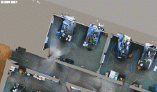
NavVis, the German provider of reality capture and digital factory solutions, is capturing BMW Group’s worldwide plants and making the photorealistic panoramic images, floor plans and point cloud data available...

NavVis is partnering up with AVEVA to provide users with the technology to access reliable as-built 3D point cloud data and panoramic images. NavVis is known for its advanced reality capture,...

A new collaboration between NavVis and NVIDIA Omniverse is aimed at enabling streaming large-scale reality-capture data for factories. This will allow not only physically accurate, computer-designed models, but also accurate 3D...
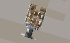
NavVis, the leading global provider of indoor spatial intelligence technology and solutions for enterprises, has announced the release of NavVis IndoorViewer 2.4. The software release includes an option to automatically...
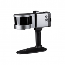
ComNav has announced the launch of its latest innovation: the LS300 3D laser scanner. This addition to the company's product lineup signifies a significant leap forward in addressing the dynamic...
It can still be difficult to achieve centimetre-level accuracy in mobile mapping, especially in GNSS-denied or challenging areas such as in deep urban canyons, under foliage or through tunnels. However,...
This site uses cookies. By continuing to use this website, you agree to our Cookies Policy. Agree