Geospatial Data in Support of 3D Cadastre
The urbanization trend is leading to an increasing number of people living in cities, thus also placing new demands on cadastral registration. To be able to register the complex infrastructures...
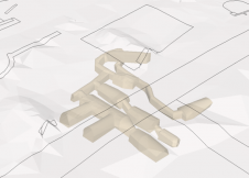
The urbanization trend is leading to an increasing number of people living in cities, thus also placing new demands on cadastral registration. To be able to register the complex infrastructures...
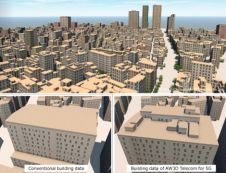
NTT DATA, an IT services provider, has announced the launch of AW3D Telecom for 5G, an advanced 3D digital map package that leverages high-quality satellite imagery for the planning of...
Esri has announced the publication of Switching to ArcGIS Pro from ArcMap. The workbook offers existing ArcMap users a road map to successfully transition from using Esri ArcGIS Desktop software's ArcMap application...
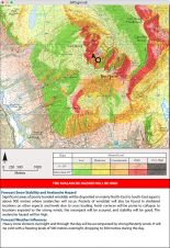
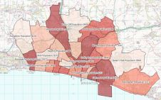
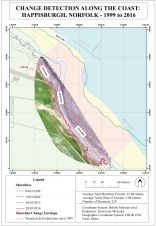
Annually, snow avalanches in Scotland are the cause of a significant loss of life. As a naturally occurring disaster they are unique in nature, usually being highly localised events, and...
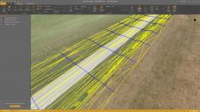
The UAV surveying software Virtual Surveyor has eliminated the need for clients to use third-party applications to prepare data for processing. Newly released Virtual Surveyor 6.1 now handles on-the-fly projections...
Cadcorp, the UK based developer and supplier of GIS and web mapping software, has announced its latest release – Cadcorp SIS 9. The Cadcorp SIS suite of GIS products is...
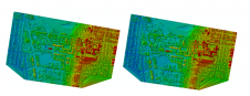
Automated measurement of the third dimension of urban growth is a crucial requirement for future urban planning and monitoring. Airborne Lidar is increasingly being used to produce regular time-based data...
Ordnance Survey (OS) has released its first fully automated product derived from large-scale source data. This means that users can now create a premium national dataset using the most up-to-date...
UAS (Unmanned Airborne Systems) are rapidly becoming a valuable source of data for inspection, surveillance, mapping and 3D modelling projects. Investment in the commercial UAS industry - estimated to increase...
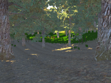
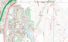
A forest management project in Quebec offers the local community a 3D virtual experience of the changes based on GIS data from a Lidar survey, as well as a digital...
This site uses cookies. By continuing to use this website, you agree to our Cookies Policy. Agree