Geo Week announces sneak peek of 2024 keynote lineup
The organizers of Geo Week have released a preview of two keynote sessions for 2024: 'The Bright Future Ahead: Navigating AEC, 3D, and Geospatial Innovation and Change', and 'Geospatial for...

The organizers of Geo Week have released a preview of two keynote sessions for 2024: 'The Bright Future Ahead: Navigating AEC, 3D, and Geospatial Innovation and Change', and 'Geospatial for...

SI Imaging Services (SIIS) has expanded its array through a new partnership agreement with satellite imaging platform company SkyFi which gives SkyFi access to SIIS’s VHR Korean Multi-Purpose Satellite (KOMPSAT)...
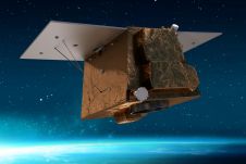
Airbus Defence and Space will manufacture Angeo-1, Angola's first very high-performance Earth observation satellite, in France. This agreement marks a significant step towards strengthening the collaboration between the two countries,...
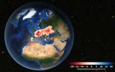
Europe is suffering from a severe drought. Satellite data analysed at TU Graz's Institute of Geodesy confirms that groundwater levels have been consistently low since 2018. Although extreme weather events...
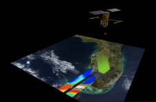
SpaceX, the space exploration company, launched a research satellite into orbit on Friday 16 December 2022. Named SWOT (Surface Water and Ocean Topography), the satellite – which is the size...
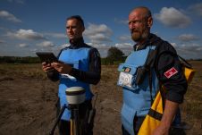
Trimble has announced a partnership with the HALO Trust, the world’s largest landmine-clearing non-profit organization, to help expand its demining operations across Ukraine. The grant from the Trimble Foundation Fund...

Remote sensing projects often begin with the question: 'Should I use aerial imagery or satellite imagery?'. During long-term projects, this question may arise again, particularly when unforeseen circumstances change the...

King Abdullah University of Science and Technology (KAUST) and its partner Spire Global have successfully launched a Cubesat satellite on the SpaceX Transporter-7 mission from Vandenberg Space Force Base in...

Harxon demonstrated its dedication to innovation at Intergeo 2023 by introducing two products designed to advance high-accuracy positioning within the geospatial industry: the Survey GNSS Antenna (HX-CSX600A) and the Helix...

Despite first being published a couple of years ago, this article on InSAR is still topical, accurate and extremely relevant in the context of aerial mapping and Earth observation. Interferometric...
This site uses cookies. By continuing to use this website, you agree to our Cookies Policy. Agree