Free Live Training Seminar-Introduction to ArcSDE
A new live training seminar from ESRI Virtual Campus, Introduction to ArcSDE, is designed for users who want to explore the features and best practices of ArcSDE. Attendees will learn...
A new live training seminar from ESRI Virtual Campus, Introduction to ArcSDE, is designed for users who want to explore the features and best practices of ArcSDE. Attendees will learn...
SimActive, the Canada-based developer of the Correlator3D photogrammetry software suite, announces a new training programme for drone mapping. The programme’s goal is to provide educational material and resources on how...
Topcon GB & Ireland has supported the launch of a new teaching guide for Class Of Your Own’s (COYO) Design Engineer Construct! (DEC!) learning programme. The guide has been designed...
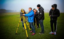
This three-day IPD (and a technical visit) aims to build capacity in the area of 3D land and property information, primarily for land and/or spatial professionals working in government and...
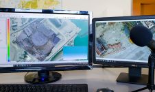
PCI Geomatics, a world-leading developer of remote sensing and photogrammetric software and systems, has announced the availability of its Synthetic Aperture Radar (SAR) image analysis in Geomatica online training sessions....
The third International and Professional Training Course for Surveyors that took place in Athens, Greece, from 3rd to 14th October 2011 ended with great success and didactic results for the...
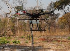
British mine-clearance charity The HALO Trust partnered with Routescene to undertake a UAV Lidar project in Cuito Cuanavale, in the Angolan province of Cuando Cubango. This case study demonstrates the...
ESRI Virtual Campus and Trimble (both CA, USA) will present a free live training seminar 23 June 2005, at 9:00 a.m., 11:00 a.m., and 3:00 p.m., Pacific time. The seminar...
The inscription for 'Digital Photogrammatry' and ' Sensor Orientation (2): Precise trajectory and attitude determination with INS' of the IG training programme in the frame of the international Master of...
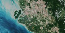
IBM and the open-source AI platform Hugging Face are collaborating to make IBM's watsonx.ai geospatial foundation model accessible to the geospatial business professionals community. This model, developed from NASA's satellite data,...
This site uses cookies. By continuing to use this website, you agree to our Cookies Policy. Agree