Exceeding All Limits
This year’s Intergeo, to be held at the Exhibition Centre in Düsseldorf, Germany from 4th to 6th October, is expected to exceed all limits. With opening extended to three whole...
This year’s Intergeo, to be held at the Exhibition Centre in Düsseldorf, Germany from 4th to 6th October, is expected to exceed all limits. With opening extended to three whole...
SmartTech was established in 1996 in Cape Town, South Africa by the current president, Spencer Allen. The company is dedicated to the development of software for surveyors, photogrammetrists and related...
Flight Landata, Inc. (MA, USA), a remote sensing firm, is awarded US$ 10 million contract providing ERDC/TEC with authority to purchase up to US$ 10 million of Flight Landata's camera...
Atech Tecnologias Críticas of Brazil has acquired a CASI-1500 imaging sensor of ITRES, developed with RF-based remote operation capability. Also delivered is a Novatel SPAN GPS/IMU for the provision of...
NovAtel Inc. (Canada) its GPS engine is onboard Neural Robotics Inc.’s (NRI) AutoCopter Express Unmanned Aerial Vehicle (UAV) – a fully autonomous and electric-powered mini-helicopter that can be used as...
Hindustan Aeronautics Limited (HALand Infotech Enterprises Limited (IEL) (both India) have formed a joint venture (JV) company to offer engineering design services for the aerospace sector. The JV, an independent...
Magellan (France) has introduction the DG14 RTK which offer high-end precision in a low-cost GNSS unit. The DG14 RTK from Magellan is a cost-effective, sub-metre GNSS (GPS and SBAS) and...
With over 580 registered delegates from 32 countries, forty international exhibitors and nearly a hundred abstracts submitted, the eighth annual International Lidar Mapping Forum(ILMF) reflected the growing importance of Lidar...
Hemisphere GPS (Canada) has entered into a definitive agreement with BEELINE Technologies Pty Ltd. under which Hemisphere GPS has agreed to acquire all of the outstanding shares and ongoing operations...
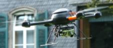
Orbit Geospatial Technologies (Belgium) has presented the Microdrone Aerial Mapping solution at Intergeo. The Microdrone UAV is a small autonomous, ultra light and very stable aireal vehicle that can be...
This site uses cookies. By continuing to use this website, you agree to our Cookies Policy. Agree