China Leaps Ahead with Geospatial Research
Prof. Dr John van Genderen, himself a leading western expert on geospatial developments in China, interviews Professor Dr ZHANG Jixian, acting president of the Chinese Academy of Surveying and Mapping...
Prof. Dr John van Genderen, himself a leading western expert on geospatial developments in China, interviews Professor Dr ZHANG Jixian, acting president of the Chinese Academy of Surveying and Mapping...
Prof. Dr John van Genderen, himself a leading western expert on geospatial developments in China, interviews Professor Dr ZHANG Jixian, acting president of the Chinese Academy of Surveying and Mapping...
The next phase in GIS development on the internet should restore user freedom and give a fully comprehensive overview of geo-objects originating anywhere and containing all relevant information. It should...
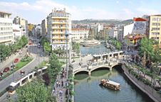
Traditional methods of information management are hard to use in the planning process of problematic urban areas such as squatter settlements. GIS provides the capability for dynamic query and analysis,...
Availability of (geospatial) data in Africa always has, and still does represent a bottleneck. Poor communications infrastructure, lack of funds, price of geospatial data and a poor distribution network are...
Availability of (geospatial) data in Africa always has, and still does represent a bottleneck. Poor communications infrastructure, lack of funds, price of geospatial data and a poor distribution network are...
This year’s annual conference of the American Society for Photogrammetry and Remote Sensing (ASPRS) took place from 7th to 11th March, with the theme ‘Geospatial Goes Global: From Your Neighbourhood...
The second annual Intergeo-East for professionals from south-eastern Europe, especially the former countries of Yugoslavia, took place at Zagrebac¢ki velesajam (Zagreb Fair), Croatia from 7th to 9th March 2005. Zagreb...
The first permanent earth observation satellite, today known as Landsat 1, was launched 33 years ago. With a ground resolution of 80 metres, the Landsat Multispectral Scanner images provided an...
In the city of Manica, a planning exercise based on the principles of participatory community planning is currently taking place in the Josina Machel neighbourhood. The city is one of...
This site uses cookies. By continuing to use this website, you agree to our Cookies Policy. Agree