Geo Connect Asia 2024 to unveil geospatial's transformative power
Geo Connect Asia (GCA) is set to return to the Sands Expo and Convention Centre in Singapore on 6 March and 7 March 2024. Since its establishment in 2019, GCA...

Geo Connect Asia (GCA) is set to return to the Sands Expo and Convention Centre in Singapore on 6 March and 7 March 2024. Since its establishment in 2019, GCA...
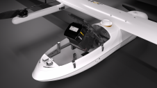
JOUAV has released the JoLiDAR-1000 Lidar sensor designed specifically for uncrewed aerial vehicles (UAVs or ‘drones’) as the latest addition to its array of high-performance Lidar sensors for use in...
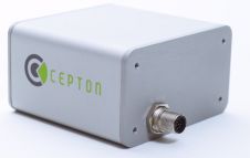
Cepton Technologies, a provider of 3D LiDAR solutions for automotive, industrial, and mapping applications, has announced the addition of two new LiDAR products, Vista-M and Vista-X, to its product portfolio....

Global reference systems such as the International Terrestrial Reference Frame provide the foundation for determining positions on Earth and in space, as well as for reliably quantifying our planet’s changes...

Lidaretto is flexible and compact Lidar scanning system developed since 2015 and uniquely designed to be used the way that fits best to users’ specific application. You can easily mount...

The Global Spatial Data Infrastructure Association (GSDI) promotes international cooperation and collaboration in support of local, national and international spatial data infrastructure (SDI) developments that will allow nations to better...
The construction of iconic towers such as the 828-metre high Burj Khalifa (formerly Burj Dubai), officially inaugurated on 4th January 2010 in Dubai, poses many challenges to surveyors. Tall towers...

The EAASI Summit 2023 in Lisbon in November was a resounding success. While the aerial surveying association’s fifth annual gathering highlighted the growing unity within the industry, there was also...
Airbus Defence and Space and ZF Friedrichshafen AG, a system provider for mobility, are collaborating to enrich and complement ZF's on-board system to enhance autonomous driving by using Airbus satellite-derived...
This site uses cookies. By continuing to use this website, you agree to our Cookies Policy. Agree