New UN organization to highlight the value of geodesy
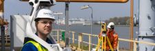
The brand-new United Nations Global Geodetic Centre of Excellence (UN-GGCE) is now operational at the United Nations campus in Bonn, Germany. Nicholas Brown, head of office of the UN-GGCE, is...

The brand-new United Nations Global Geodetic Centre of Excellence (UN-GGCE) is now operational at the United Nations campus in Bonn, Germany. Nicholas Brown, head of office of the UN-GGCE, is...

The Australian government has committed to participating in Landsat Next, a groundbreaking satellite initiative spearheaded by NASA and the US Geological Survey. This programme aims to comprehensively map and monitor...
In the first episode of NavVis’ new podcast series, we hear revelations from world experts about the past, present and future of reality capture and documentation. In the first episode of NavVis’ new podcast series, we hear revelations from world experts about the past, present and future of reality capture and documentation. ‘Scanning Realities’ is the...
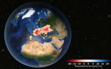
Europe is suffering from a severe drought. Satellite data analysed at TU Graz's Institute of Geodesy confirms that groundwater levels have been consistently low since 2018. Although extreme weather events...
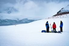
Capturing and measuring the environment in the Arctic and Antarctic is a particularly challenging job. The area of interest is often covered by a thick blanket of snow and ice,...

Roderik Lindenbergh is an associate professor at the Department of Geoscience and Remote Sensing, Delft University of Technology, the Netherlands. He obtained his PhD in Mathematics from Utrecht University, the...
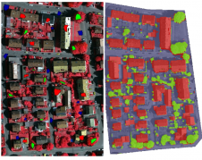
This article outlines a generic workflow for automatic buidling detection and 3D modelling using modern technologies, to support applications ranging from urban planning and cadastre to change detection and navigation....
Bentley Systems, the infrastructure engineering software company, is to acquire Seequent – a leader in software for geological and geophysical modelling, geotechnical stability and cloud services for geodata management, visibility and...
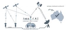
Australia and New Zealand’s operational Satellite Based Augmentation System (SBAS) has officially been named the Southern Positioning Augmentation Network, or SouthPAN. SouthPAN will be the first SBAS in the Southern...

How are technological developments, skills shortages and the pandemic affecting the broader geospatial community in Australia? To find out, GIM International spoke to Paul Digney, president of the Surveying and...
This site uses cookies. By continuing to use this website, you agree to our Cookies Policy. Agree