Advanced Laser Imaging Ltd

Both vertical and oblique aerial images have their own advantages, making them valuable in different reality mapping applications. So how can you choose between the two? This comparison will help...
It can still be difficult to achieve centimetre-level accuracy in mobile mapping, especially in GNSS-denied or challenging areas such as in deep urban canyons, under foliage or through tunnels. However,...

In a high-flying endeavour spanning over six decades, the UK’s National Grid's fleet of advanced helicopters have been diligently patrolling pylons and power lines, ensuring the health and reliability of...
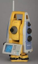
Topcon's Imaging Station, the IS-3, increases the longest scanning range to 6,500 feet (2,100m). Its patented prism tracking scanning interface technology X-TRAC 8 has, according to senior vice president of...
CGGVeritas has inaugurated a new open Processing & Imaging center in Muscat, Oman at a ceremony attended by clients and a delegation from the Omani Ministry of Oil & Gas....
This site uses cookies. By continuing to use this website, you agree to our Cookies Policy. Agree