Peak performance in mobile mapping
It can still be difficult to achieve centimetre-level accuracy in mobile mapping, especially in GNSS-denied or challenging areas such as in deep urban canyons, under foliage or through tunnels. However,...
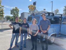
It can still be difficult to achieve centimetre-level accuracy in mobile mapping, especially in GNSS-denied or challenging areas such as in deep urban canyons, under foliage or through tunnels. However,...

There are indications that today’s technological advances are putting a fully operational multipurpose cadastre within reach, following decades of a global vision and small-scale progress towards a comprehensive map-centric land...
SimActive has unveiled the enhancement of Correlator3D for improved cloud environment productivity. With Correlator3D’s distributed processing capabilities, clients can seamlessly scale their processing in line with operational needs. The challenges...

Both vertical and oblique aerial images have their own advantages, making them valuable in different reality mapping applications. So how can you choose between the two? This comparison will help...

Founded in 2017, ZZCOMM technology of geospatial hardware and software solutions provides rapid and high-accurate geospatial data for BIM, mining AEC, survey and mapping industries, whether they are indoor, outdoor,...
Orbit GT has released its premiere indoor mapping product with a broad range of functionalities. Indoor Mapping v17 is a solution for point cloud and imagery management, floor plan building...
Few museums, shopping centres, airports and other indoor spaces have been mapped, although the demand for detailed 3D models of such spaces is accelerating rapidly. Here, the authors present a...
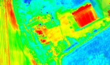
Topodrone has recently unveiled a cutting-edge drone thermal mapping solution: the Topodrone PT61 camera, designed to conduct detailed surveys and generate thermal orthomosaic maps, facilitating the creation of accurate 3D...
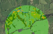
The UK’s Peak District National Park Authority is pioneering the use of artificial intelligence (AI) to automate the production of highly detailed land cover maps, in a project in partnership...
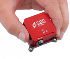
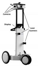
At Intergeo, SBG Systems has joined VIAmetris in announcing the MID, a SLAM-based portable indoor mapping system. For this innovation, VIAmetris has chosen SBG Systems’ brand new miniature AHRS, the...
This site uses cookies. By continuing to use this website, you agree to our Cookies Policy. Agree