GEO Business 2024: unlocking geospatial innovation at ExCeL London
GEO Business, the UK’s premier geospatial event, is celebrating its tenth anniversary when it returns to ExCeL London on 5 and 6 June 2024. This edition promises to be the...

GEO Business, the UK’s premier geospatial event, is celebrating its tenth anniversary when it returns to ExCeL London on 5 and 6 June 2024. This edition promises to be the...

Diamond Aircraft has delivered the new DA62 MPP SurveyStar to RIEGL. Setting a new standard for high-capability, low-cost airborne survey missions, this robust and modern survey configuration variant of the...

Fujitsu has presented a pioneering technology that harnesses Lidar and AI to capture high-resolution 3D data of organisms, coral reefs and man-made structures such as offshore wind turbines using autonomous...

Looq AI has announced the launch of its groundbreaking AI-enabled digital twin technology, the Looq platform. Positioned as a one-stop solution, it allows surveyors, engineers, contractors and asset owners to...

The brand-new United Nations Global Geodetic Centre of Excellence (UN-GGCE) is now operational at the United Nations campus in Bonn, Germany. Nicholas Brown, head of office of the UN-GGCE, is...

In the ever-evolving landscape of climate change, geospatial science emerges as a key player in navigating the complexities of our transforming world. The European Association of Aerial Surveying Industries (EAASI)...

Looking for a recipe for business success in surveying? Don't underestimate the importance of innovative surveying services, says Moritz Lauwiner. The latest measurement sensors and software, decades of collective experience...

The fourth edition of Geo Connect Asia (GCA), celebrated as the region's premier trade event and conference for the geospatial, positioning and remote sensing industries, truly delivered during its two-day...

Despite some uncertainty, there is renewed interest in drones, and remote sensing technologies are being embraced by smaller survey companies. Read these and other findings from our annual industry survey!...
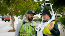
Join Noah Eckhous from NavVis and Mike Walle from Denn Engineers in downtown Culver City to explore how SLAM-based data capture technology transforms topographic survey workflows. In this video, we...
This site uses cookies. By continuing to use this website, you agree to our Cookies Policy. Agree