Geo Connect Asia 2024 to unveil geospatial's transformative power
Geo Connect Asia (GCA) is set to return to the Sands Expo and Convention Centre in Singapore on 6 March and 7 March 2024. Since its establishment in 2019, GCA...

Geo Connect Asia (GCA) is set to return to the Sands Expo and Convention Centre in Singapore on 6 March and 7 March 2024. Since its establishment in 2019, GCA...

Visitor registration is now open for GEO Business, the UK's largest geospatial event. The free-to-attend expo, tailored for geospatial professionals seeking to harness the potential of location intelligence, will return...

The Icelandic authorities have commissioned Acecore to map the extent and aftermath of the Eldvörp-Svartsengi volcanic system eruption using its high-end drone solutions. Grindavík, a fishing village on the Reykjanes...
The full feature is online at http://member.gim-international.com/. Please subscribe for free using the Subscribe button in the left hand column. The rate of data growth is increasing exponentially, thanks to...

1Spatial has successfully secured a three-year contract with a leading distribution system operator for electricity and gas networks in Belgium. The contract, awarded after a competitive tender process, will involve...

Global reference systems such as the International Terrestrial Reference Frame provide the foundation for determining positions on Earth and in space, as well as for reliably quantifying our planet’s changes...

Two expert organizations in authoritative geospatial data, cartography and GIScience have announced a new international collaboration to demonstrate the power of location. Members of EuroGeographics, the not-for-profit association for European...
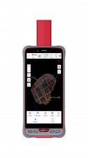
ComNav Technology has introduced its new handheld P6H. This advanced and rugged device is tailor-made for GIS data collection and outdoor operations. Featuring a GNSS high-precision positioning module, rugged IP67-rated...

GrabMaps is preparing to launch KartaCam 2, a crowdsourced mapping solution combining high-end imagery and AI capabilities to transform local expertise into effective navigation solutions. With the introduction of enhanced...

Maxar Intelligence has been awarded a contract to supply the National Geospatial-Intelligence Agency (NGA) with a Precision3D Data Suite bundle. This comprehensive package covers an extensive area of 160,000 square...
This site uses cookies. By continuing to use this website, you agree to our Cookies Policy. Agree