Stonex
Stonex is an Italian company, world leader in measurement and surveying. The head office is near Milan and the American headquarters is in Concord, USA. The company also has a...

Stonex is an Italian company, world leader in measurement and surveying. The head office is near Milan and the American headquarters is in Concord, USA. The company also has a...

Global reference systems such as the International Terrestrial Reference Frame provide the foundation for determining positions on Earth and in space, as well as for reliably quantifying our planet’s changes...

Over the past 20 years, various initiatives have been launched reflecting the importance of cadastral data for land management and spatial development. But how have these initiatives enhanced the possibility...

Dublin City University (DCU) has partnered with Bentley Systems to spearhead the creation of an advanced digital twin of its campus as a pivotal element of its Smart DCU initiative....
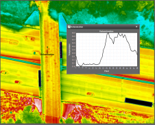
NV5 Geospatial's thermal infrared (TIR) solutions for transportation infrastructure challenges are currently being implemented in projects to analyse concrete bridges in the USA's Midwest. NV5 Geospatial, a leading geospatial data...

The number of wildfires has increased dramatically in recent years due to diminishing forest health caused by the drastically changing climate across the world. Longer dry-weather periods and pressure from a variety of pests and diseases, e.g. bark beetles, are affecting the large forest areas in Northern Europe. In addition to financial losses, these impacts are resulting in lower carbon accumulation and vast ecological changes. The number of wildfires has increased dramatically in recent years due to diminishing forest health caused by the drastically changing climate across the world. Longer dry-weather periods and pressure from...

Planet was founded with the mission to image the Earth every day and make change visible, accessible, and actionable. Over the past decade with our customers, Planet has revolutionized the...
Innovative methodologies based on artificial intelligence (AI) are lowering the barriers and democratizing the use of 3D digital twins in the geospatial industry. Digital twins are revolutionizing the geospatial industry,...
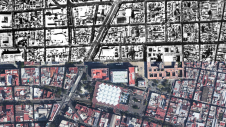
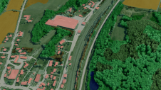
Over the past 15 years, geospatial information has enabled the transformation of towns, cities and a whole state in Mexico. The customer and data provider teamed up to create up-to-date...
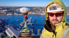
The revolutionary use of active GNSS control points and cutting-edge geomatics equipment is setting new standards for accuracy in the construction of high-rise architecture, as demonstrated by this skyscraper project...
This site uses cookies. By continuing to use this website, you agree to our Cookies Policy. Agree