Moritz Lauwiner
Moritz Lauwiner is executive vice president and president of the Geomatics division at Hexagon’s Geosystems division. In this role, he oversees research and development, business strategy and overall management of...

Moritz Lauwiner is executive vice president and president of the Geomatics division at Hexagon’s Geosystems division. In this role, he oversees research and development, business strategy and overall management of...

3D visualization is at the heart of many geospatial data applications. Progress in 3D visualization has drastically reduced barriers to entry for new products based on large datasets, thanks to...

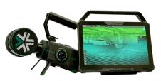
Klau Geomatics has introduced the Brumby RTK Lidar system, an innovative mobile mapping solution equipped with powerful Edge Compute capabilities, enabling the generation of highly precise georeferenced point clouds in...
Exyn Technologies has unveiled Exyn Nexys, an innovative modular 3D mapping solution. Designed for professionals in the mining, construction, AEC and geospatial industries, Nexys aims to set a new standard...

Geo Connect Asia (GCA) is set to return to the Sands Expo and Convention Centre in Singapore on 6 March and 7 March 2024. Since its establishment in 2019, GCA...

EuroGeographics is drawing attention to the indispensable role of official national geospatial data in enhancing Copernicus Services, particularly within land monitoring and emergency management. This highlights a reinforced partnership between...

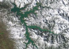
The Icelandic authorities have commissioned Acecore to map the extent and aftermath of the Eldvörp-Svartsengi volcanic system eruption using its high-end drone solutions. Grindavík, a fishing village on the Reykjanes...
PlanetScope is now accessible on Google Cloud Marketplace. This availability of Planet's flagship satellite imaging product contributes to the company's mission to democratize access to near-daily satellite imagery, enabling organizations...
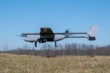
In a new strategic partnership, Inertial Labs' RESEPI Payload Lidar technology will be integrated into E38's advanced E455 drone platform. This collaboration marks a significant milestone in the utilization of...
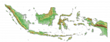
Intermap has won a US$20 million contract to map the Indonesian island of Sulawesi this year. The contract is the first phase of the Indonesian national topographic basemap programme to...
This site uses cookies. By continuing to use this website, you agree to our Cookies Policy. Agree