Monitoring Vulcanoes with UAS
Insight into signs that prelude volcanic eruptions is key for protecting the lives, livestock and property of those living in the vicinity of a volcano. One key indicator is temperature...
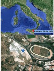
Insight into signs that prelude volcanic eruptions is key for protecting the lives, livestock and property of those living in the vicinity of a volcano. One key indicator is temperature...
3D Laser Mapping, UK, has published the programme of speakers for its forthcoming International Slope Monitoring Conference. Taking place on 25 and 26 July 2012 in Mokopane, South Africa, the...
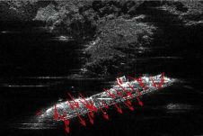
TRE and the Polytechnic University of Milan, Italy, in collaboration with the Department of Earth Sciences (University of Florence) have been monitoring the movement of the partially sunk cruise ship...
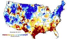
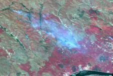
The record-breaking drought in Texas, USA, that has fuelled wildfires, decimated crops and forced cattle sales has also reduced groundwater levels in much of the state to their lowest levels...
Wildfires in Yakutia, Russia, are being monitored by ScanEx specialists. Over the past week UniScan ground stations have received highly detailed optical images from the SPOT 5 satellite covering one...
More than 200 researchers from over 24 countries congregated at the biennial POLinSAR workshop held at European Space Agency’s (ESA) centre for Earth observation in Italy. The workshop aimed to...
Trimble has introduced today two new features for its Trimble 4D Control software solution for monitoring systems. The features include support for geotechnical sensors and a user-friendly Web Module. The...
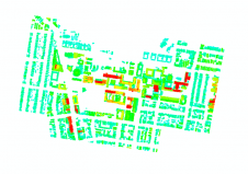
This innovative approach to measuring 3D urban growth integrates Lidar processing with machine learning. It takes account of the specific needs of urban planners, is less complicated to run and...
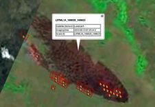
Testing of the operational ScanEx Fire Monitoring Service (SFMS) has been started. The service has been developed at the ScanEx Research and Development Center and unlike similar systems (e.g., NASA...
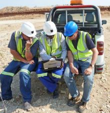
A group of Saudi Arabian and European partners have completed a project to implement and provide satellite based environmental information products and services to the Presidency of Meteorology and Environment...
This site uses cookies. By continuing to use this website, you agree to our Cookies Policy. Agree