Oleg Vassilev
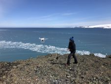
Oleg Vassilev has been contributing to the Bulgarian Antarctic campaigns since 2017. One of his focuses is drone-based photogrammetry data collection necessary for glaciological and biological observations to study the...
Oleg Vassilev has been contributing to the Bulgarian Antarctic campaigns since 2017. One of his focuses is drone-based photogrammetry data collection necessary for glaciological and biological observations to study the...
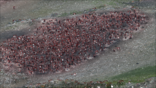
Remote sensing surveys in Antarctica based on unmanned aerial vehicles (UAVs or ‘drones’) have become a very important approach for a wide range of studies. Mapping free-from-ice-and-snow terrain and monitoring...
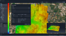
SimActive has announced the release of Correlator3D Version 10. This latest version comes with a completely redesigned user interface, featuring a new dark mode option, and also allows for point...
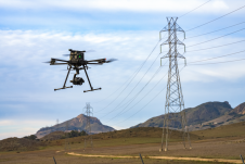
Inspired Flight Technologies and Phase One have jointly launched a new plug-and-play solution that combines aerial imaging and flexible operations to meet diverse surveying and inspection needs. Inspired Flight Technologies...

Prof Bisheng Yang is currently a professor of Geomatics Engineering and the director at the State Key Laboratory of Information Engineering in Surveying, Mapping, and Remote Sensing of Wuhan University....

Yuzhou Zhou received an MSc degree in Photogrammetry and Remote Sensing from Wuhan University, China, in 2022. He is currently a DPhil student in the Department of Computer Science at...
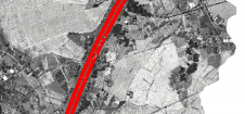
Thanks to rapid improvements in aerial laser scanning systems, they offer great potential in road surveying compared with traditional photogrammetry-based methods. Using the high-density 3D point clouds resulting from aerial...

To find out more about the geomatics education situation across the globe, 'GIM International' spoke to several industry experts from academia around the world. Are the numbers of students in...
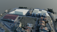
To explore the contribution of UAVs to the spatial mapping process in urban environments, a team from Greece studied the use of aerial imagery to achieve wide coverage of a...

UP42, a geospatial developer platform and marketplace, has expanded its aerial imagery and elevation data portfolio through a partnership with Vexcel, a 30-year industry leader in photogrammetry and remote sensing....
This site uses cookies. By continuing to use this website, you agree to our Cookies Policy. Agree