Photogrammetry and Remote Sensing

Germany-based technology company nFrames develops cutting-edge 3D surface reconstruction software designed for professional mapping production. Optimised for precision, speed and simplicity, the company’s core software product, SURE, is built to...

The race between data production and processing capacity has been going on for many decades, with data production usually on the winning team. This is also true for airborne and...
Innovative methodologies based on artificial intelligence (AI) are lowering the barriers and democratizing the use of 3D digital twins in the geospatial industry. Digital twins are revolutionizing the geospatial industry,...
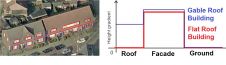
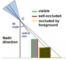
Multiple view oblique imagery of very high resolution is a rich source of semantic information about buildings and other objects on the Earth’s surface. The efficient extraction of semantic information...
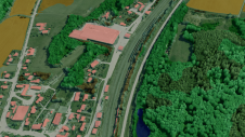
Oblique airborne photogrammetry is rapidly maturing and entering the workflow of service providers. Many applications embrace the advantages of airborne capturing combined with slanted viewing geometry which comes close to...
Orbit GeoSpatial Technologies has released its photogrammetric UAS mapping application of Orbit Strabo Photogrammetry 10.5, and the update is immediately available for download. This upgrade adds new features on several...
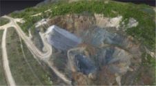
UAS mapping is widely accepted as a new method for acquiring spatial image data. The main business opportunities clearly lie in projects which are too small to be of interest...
Sanborn has selected SimActive Correlator3D as its new platform of choice. With immense data volumes traversing complex production workflows, Sanborn required a new photogrammetry suite for handling projects efficiently. "The...
This site uses cookies. By continuing to use this website, you agree to our Cookies Policy. Agree