History
To be honest, I had completely overlooked the link as well. And that doesn’t say much for me, a historian by trade. Okay, a few months as publication director with...
To be honest, I had completely overlooked the link as well. And that doesn’t say much for me, a historian by trade. Okay, a few months as publication director with...
There are professions in our society that are almost invisible. Mine certainly isn’t one of them. Publishers know how to make use of the media to show the world what...
The Government of India on 19th May 2005 approved a radical New National Map Policy, ending decades of restrictive practise that had hampered geospatial development on the subcontinent (see Pinpoint...
The Government of India on 19th May 2005 approved a radical New National Map Policy, ending decades of restrictive practise that had hampered geospatial development on the subcontinent (see Pinpoint...
Historians increasingly use the computer for analysing spatial effects and perspective spaces in ways that were hitherto impossible. The authors provide examples of their extensive work on computer modelling of...
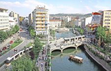
Traditional methods of information management are hard to use in the planning process of problematic urban areas such as squatter settlements. GIS provides the capability for dynamic query and analysis,...
Excessive groundwater extraction is probably the main factor causing land subsidence in urban areas of Indonesia. Decreases in groundwater level may reach 15 metres a year. Monitoring of land subsidence...
On January 12th 2006 came the announcement that Orbimage had acquired Space Imaging. The newly formed company, GeoEye, flies the high-resolution Ikonos, Orbview-3 satellites and Orbview-2. In 2007 it will...
On January 12th 2006 came the announcement that Orbimage had acquired Space Imaging. The newly formed company, GeoEye, flies the high-resolution Ikonos, Orbview-3 satellites and Orbview-2. In 2007 it will...
This year’s Intergeo, to be held at the Exhibition Centre in Düsseldorf, Germany from 4th to 6th October, is expected to exceed all limits. With opening extended to three whole...
This site uses cookies. By continuing to use this website, you agree to our Cookies Policy. Agree