Amy Nicol
Amy Nicol is the sales and marketing assistant at Slovenian geospatial software 3Dsurvey. She has over a decade of experience in sales and communication, working in an array of different...

Amy Nicol is the sales and marketing assistant at Slovenian geospatial software 3Dsurvey. She has over a decade of experience in sales and communication, working in an array of different...

Matija Zupan is a certified drone operator and QA manager at Slovenian geospatial software developer 3Dsurvey. He made his way into photogrammetry through geology, geotechnical engineering, and natural hazard modelling...

Videogrammetry can be seen as a natural progression from photogrammetry. So how can videogrammetry improve and enhance data collection for surveying professionals? This article explores its intricacies through case studies,...

London Gatwick has created a new geospatial platform using Esri’s ArcGIS to support multiple operational areas at the airport, including engineering and environmental services. The system is already making engineering...

Looq AI has announced the launch of its groundbreaking AI-enabled digital twin technology, the Looq platform. Positioned as a one-stop solution, it allows surveyors, engineers, contractors and asset owners to...

RSK Group has awarded a new enterprise GIS contract to Esri UK to boost the use of geospatial technology across its operations and support ambitious growth plans. This three-year agreement,...

The Nemetschek Group and Hexagon’s Geosystems division are poised to establish a strategic partnership aimed at accelerating the digital transformation of their industries. As a crucial initial step, the partnership...

Moritz Lauwiner is executive vice president and president of the Geomatics division at Hexagon’s Geosystems division. In this role, he oversees research and development, business strategy and overall management of...

Looking for a recipe for business success in surveying? Don't underestimate the importance of innovative surveying services, says Moritz Lauwiner. The latest measurement sensors and software, decades of collective experience...
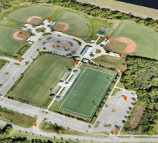
SimActive has reported that the use of its Correlator3D product along with ground control points can enhance, extend and validate photogrammetry projects. GCPs are critical in photogrammetry projects, but there...
This site uses cookies. By continuing to use this website, you agree to our Cookies Policy. Agree